The 18 UTC (11 am) weather map shows the boundary between the cold continental air and our relatively warm desert airmass. You can see the striking differences in temperatures in the Eastern Plains and west of the Rio Grande. Air temperatures were 14F in Hobbs and 45F in Deming with more than 20F difference in dew point between the two.
As of 2 pm I haven't seen any precipitation on the NMSU campus yet but reports of snow in Alamogordo and in the Sacramento Mountain towns. Here is the view to the west up till 3 pm today.
The Sunland Park City Yard station had a high wind/PM event today with hourly averaged winds exceeding 13 m/s (29 mph). Peak PM10 was over 350 µg/m3 on 1 pm and again at 5 pm. Winds at the time were from the ESE with wind gusts up to 20 m/s (45 mph) in the afternoon.
At the Chaparral Station winds didn't peak as high as Sunland Park and were less than half of what we observed at the same hour there. PM10 concentrations didn't peak until the evening after 9 pm when the wind gusts were around 13 m/s. We find a similar pattern at the Anthony station with PM10 nearly 300 µg/m3 at 7 pm.
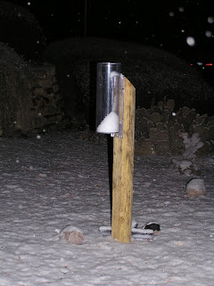
Snow started to fall in Las Cruces around 7 pm and lasted for at least an hour with around an inch of snow on the ground at 9 pm. Photo below was taken at 8:30 pm on my rain gauge.


No comments:
Post a Comment