Showing posts with label Low wind event. Show all posts

Monday, February 6, 2012

Feb. 6 -

Low wind event tonight at the SPCY station.

It's been a little while since I've reported to the blog.  The AQI forecast shows good air quality over the border region for Monday. You might keep in mind that the SPCY events are local phenomena and not that representative of the region and typically will not show up in the AQI forecast. Occasionally we do get stagnation events that are predicted by the models with a persistent subsidence inversion over the area.

Monday, January 30, 2012

Jan. 30 -

Clear skies and fair weather on course for today. The forecasted high temperature for Las Cruces is 64F with westerly winds 11 mph today. A low wind PM event occurred tonight at the SPCY station with peak hourly PM2.5 reaching 30 µg/m3 at 8 pm.


The AQI forecast shows moderate air quality over Dona Ana county due to ozone. An AQI of 52 is expected in this region.  As of 1 pm ozone concentrations are 40 ppb in SPCY and 42 ppb in Las Cruces and not enough to trigger moderate levels at the one hour averaging period.

The low temperatures in Alaska are still amazing me.  I mentioned the Jim River DOT station (JMTA2) near Prospect Creek, Alaska. The low temperature dipped to -79F before the station stopped communicating on Saturday. The dewpoint temperature reported by the station was -91.6F (38% RH) at the time. Since the trend at the time of the failure was going down in temperature, folks are wondering if the US record low temperature was broken at this station on Saturday. Recall that the current record of -80F was taken near this station back in 1971.  I'm curious on how accurate the sensors are for these kind of extreme temperatures. The following two photos were taken by Dr. Uma Bhatt at the University of AK in Fairbanks showing the ice fog that blankets the area.
This afternoon the Fairbanks NWS forecast office has posted that the Jim River DOT station should not be considered for any records since the sensors are not rated for such low temperatures. The statement is given below.


NOAK49 PAFG 302352
PNSAFG
AKZ219-222-311200-

PUBLIC INFORMATION STATEMENT
NATIONAL WEATHER SERVICE FAIRBANKS AK
252 PM AKST MON JAN 30 2012

...CLARIFICATION OF TEMPERATURES FROM JIM RIVER DOT CAMP...

TEMPERATURES THIS PAST WEEKEND AT THE ALASKA DEPARTMENT OF
TRANSPORTATION JIM RIVER MAINTENANCE CAMP AT MILE 138 DALTON
HIGHWAY...STATION JMTA2...HAVE BEEN REPORTED AS LOW AS 79 BELOW.

THE TEMPERATURES ARE NOT CORRECT. THE WEATHER STATION IN USE AT
THE JIM RIVER DOT CAMP IS A PERSONAL WEATHER STATION THAT IS NOT
RATED FOR TEMPERATURE COLDER THAN 40 BELOW. THE UNREALISTICALLY
LOW TEMPERATURES ARE BELIEVED TO BE A FUNCTION OF THE BATTERY
FAILING AT VERY LOW TEMPERATURES.

THERE ARE NO OFFICIAL...NATIONAL WEATHER SERVICE STANDARD...
TEMPERATURE MEASUREMENTS AT JIM RIVER DOT CAMP.

$$
RT/JL JAN 12

Sunday, January 29, 2012

Jan. 29 -

Low wind, high PM event at the SPCY station tonight. Today's cool temperatures and light southerly winds in the 1 m/s range provided the recipe for this event. The plot below shows the PM2.5 trace as of 7 pm this evening at the SPCY from the NMED website.
Below is this morning's observations at the NMSU NWS Cooperative weather station.

                 Yesterday            Today
Station       High(F) Normal    Low(F)  Normal  Record Low Precip
NMSU            56      61       31      29       16 (1966) 0.00"

The AQI forecast for today showed an area of moderate air quality extending over all Dona Ana and El Paso counties. The moderate areas are apparently tagged for different pollutants the Airnow website. The El Paso moderate is from PM2.5 while the area in Dona Ana is due to ozone. I'll go more with the PM2.5 due to the low winds. We still have pecan harvesting going on based on my view of isolated dust plumes in the Mesilla Valley over the weekend.
I'm very happy with our temperatures here along the border compared to the cold snap going on in Alaska. They are still breaking records this morning with the Bettles, AK station reaching a low of -60F. Their previous record low was -58F set in 1989.  The low at the Jim River DOT station (JMTA2) today was warmer than yesterday but still very low at -54F.

Monday, January 23, 2012

Jan. 23 -

Sunny and breezy today.  I'm at the American Meteorological Society's Annual Meeting in New Orleans this week but still connected and following the storms that look to impact the border region.

Below are this morning's observations at a couple NWS Cooperative weather stations.

                 Yesterday            Today
Station       High(F) Normal    Low(F)  Normal  Record Low Precip
NMSU            60      58       29      29       16 (1966) 0.00"
Antelope Wells  64      62       26      28       15 (2007) 0.00"

The AQI forecast shows good air quality over the region today.
Tonight we saw a low wind, high PM event at the SPCY station.  Peak hourly PM2.5 was in the 40 ug/m3 range with winds around 1 m/s.

Going back to the AMS meeting, so far I've listened to several good talks on drought, seasonal forecsting and dealing with databases.

Tuesday, January 17, 2012

Jan. 17 -

Greetings from Roswell. Very nice weather here in east central NM today. We saw a little bit of snow on the ground in Cloudcroft but it has mostly melted except in the shaded areas. Stan and I replaced the wind sensor at the Artesia Ag Science Center in the afternoon and I've just finished the talk I'll be giving at the Southwest Beef Symposium tomorrow morning at 8 am.  I'll be giving a talk on the long term weather outlook for NM and TX.

Looks like another low wind high PM event at the SPCY site tonight.
The forecasts for the border region include warm temperatures and low winds for the next couple of days. Friday will see a change in the weather pattern as a trough passes over us and we'll likely see an increase in winds.

Saturday, January 14, 2012

Jan. 12- 14

Fairly strong low wind high PM events at SPCY over the last two days on Jan. 13 and 14.  Driving back from Tucson on Friday afternoon I saw that the playas west of Lordsburg were still very wet with a lot of water still filling the lower lying areas. The photo below shows the area around mile marker 12 on I-10 looking south.
Even though the low lying areas are saturated, the higher elevations are drying out and could yield dust if there were enough wind.

It looks like another low wind high PM epsidoe on Saturday night before the weather pattern changes.

Below are this morning's observations at a couple NWS Cooperative weather stations.
                 Yesterday            Today
Station       High(F) Normal    Low(F)  Normal  Record Low Precip
NMSU            55      58       25      27        5 (1963) 0.00"
Antelope Wells  52      60       20      25       17 (2011) 0.00"


The AQI forecast for today showed an area of moderate air quality over the southern NM and the Paso del Norte.
Sampling at the SPCY site started again tonight (Jan. 14) with a 6-hour run starting at 6 pm. The graph below shows the magnitude of the hourly PM10 and PM2.5 during the episode.
 At 11 pm the graphic below is what the NMED Air page showed for the SPCY site air quality index.
I spent the last couple of days at a Valley Fever and dust forecasting workshop in Tucson and was briefed on some of the latest research findings from those working on this disease. I am amazed at the complexity of this problem since it covers many disciplines and there are so many unknowns still after 50 years of work.  A lot of interest was stirred up from this past summer's haboob that engulfed the Phoenix area in July 2011. Some of the big questions that remain unanswered are where it is found, how it it transported from the soils to our lungs, and how long it survives in the atmosphere after leaving the soil.  The agricultural sector may be relieved that the main tilled and irrigated portions of the field is hostile to the fungi and not as likely to be a growth area. However the edges around the fields can be a more hospitable for the organism. Tucson had a bit of pollution especially noticeable in the morning with the inversion. Below is a look south toward downtown Tucson from the conference location at around 8:30am.

The battery was not charging when I visited the SPCY site on Saturday. I have not replacement items or tools so  I'll have to work on it on Sunday. There was some moisture around the datalogger box from last week so it might be related to that but not sure.


Monday, January 9, 2012

Jan. 9 -

Nice rain event in Dona Ana and El Paso counties. Most locations received more than an inch or rain with the highest at 1.08 inch. Below are this morning's observations at our NWS Cooperative weather station. I'll grab more station data when I get time today.

                 Yesterday           Today
Station       High(F) Normal  Low(F)  Normal  Record Low Precip
NMSU            60      56     30      26      8 (1964)  0.67"

Not surprising the AQI forecast for today is in the good range due to the rain wash out effects.
2pm update: Just got back from El Paso/Sunland Park and noticed the abrupt change in weather between there and Las Cruces.  Sunny in Las Cruces but still lots of cloud cover in El Paso made it feel like it was going to rain again.  I am going to postpone filter sampling at SPCY still another day.

A low intensity, low wind event unfolded at the SPCY station tonight.

Friday, January 6, 2012

Jan. 6 -
Above average temperatures and clear skies describes the weather today but weather is going to change. I like to see precipitation forecasts with actual rain and snow falling but I'm ready for the spring temperatures. Below are this morning's observations at a couple NWS Cooperative weather stations.

                 Yesterday           Today
Station       High(F)  Normal     Low(F)  Normal  Record Low
NMSU            64        56        26      28      7 (1971)
Antelope Wells  62        62        22      28     10 (2000)
Glenwood        57        55        21      25      4 (1971)


The AQI forecast is back to showing good air quality for our region today.
Looks like unsettled weather from an upper level trough for the weekend and low wind events are unlikely. The plot below is from this morning's 12Z GFS run at SPCY.
The evening ended with a low wind high PM event at the SPCY station.

Thursday, January 5, 2012

Jan. 5 -

Low wind, high PM episode at SPCY today - Warm, clear skies, and breezes describes the weather today. Below are this morning's observations at a couple NWS Cooperative weather stations.
                 Yesterday           Today
Station       High(F)  Normal     Low(F)  Normal  Record Low
NMSU            65        54        31      28      7 (1971)
Antelope Wells  65        61        25      27     10 (2000)


The AQI forecast is back to showing an area of moderate air quality for PM2.5 in the Paso del Norte today.
Particulate concentrations have been low in the region with PM10 in the 20 to 40 µg/m3 range. There is a good chance of some precipitation over the weekend as the 5-day QPF shows the storm track moving through New Mexico.
A few scattered high clouds and contrails dotted the evening sky at 5:29 pm looking west from the NMSU campus.
A low wind high PM event was unfolding starting around 7 pm at the SPCY station.
I will also add the NMED Anthony station also had a low wind high PM spike this evening although not as strong as was found at the SPCY station.

Saturday, December 31, 2011

Dec 31 -

Another low wind, high PM evening at SPCY. It warmed up to a very nice day today with some highs more than 10 degrees above average. Looking at the highs around the region, the Las Cruces airport reached 68, El Paso airport 70, and Deming 71.  Below are this morning's observations at a few NWS Cooperative weather stations.

                 Yesterday           Today
Station       High(F)  Normal     Low(F)  Normal  Record Low
NMSU            66        55        29      28      6 (1895)
Antelope Wells  71        61        29      28     17 (2010)
Hachita         64        56        23      26      6 (1958)

The Airnow AQI forecast for our region is green or good air quality. However, with the low winds today we're seeing a build up in pollutants.
I was at the SPCY station today swapping filters and I could smell a whiff of wood burning now and then the whole time I was there from 3:30 to 4:30pm.  I'm not totally sure it was wood but it had that kind of semi-sweet smell similar to when I visited an old time blacksmith's shop. There were some smoke plumes in Mexico while I was there. I took some photos but my camera corrupted the memory card.  

Here I describe the particle counter that I installed at the SPCY station.
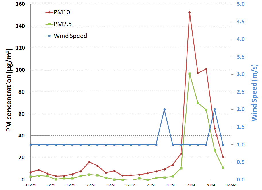
There was a 6-hour long low wind, high PM event at the SPCY station tonight. Peak hourly PM2.5 was 138 µg/m3 at 7 pm. The chart below shows the hourly PM10, PM2.5, and 10 meter wind speed from the NMED station.
The particle sizer clearly shows the low wind event with the 0.3 micron size bin increasing by a factor of 20 to 30 during the event compared to mid-day values. The chart below shows the particle count data for the 0.3 and 10 micron bins over the past two days. Up to this point we have collected enhanced data on the nature of the low wind PM spike for two episodes (highlighted in yellow).


Friday, December 30, 2011

Dec. 30 -

Forecasting another low wind event tonight. Below are this morning's observations at a couple Cooperative weather stations.
                 Yesterday           Today
Station       High(F)  Normal     Low(F)  Normal  Record Low
NMSU            59        56        29      28      4 (1895)
Hachita         64        56        23      26      6 (1969)

Temperatures have finally climbed above average in Las Cruces. The NWS forecast is calling for low winds tonight but from the north. Below is a wind forecast from the 15Z RUC model at 8 pm tonight.
 The AQI forecast for today again shows our patch of moderate air quality over the Paso del Norte and El Paso county.
Looking past the weekend and into next week the 12Z GFS forecast conditions look good for low wind events from the 3rd to 5th but after that I'm not that confident since the winds start to increase due to an upper level trough moving in to the area.
6 pm Minivols are set to run from 6pm to midnight tonight to capture a low wind high PM event. Filters used today include DUPT001 (Teflon) on sampler SN5360 and DUPQ001 (quartz) on sampler with SN5361.  I also downloaded the data from the profiler and a time series plot of particle counts for small (0.3 micron) and coarse (10 micro) is shown below. During the low wind spike yesterday, highlighted in yellow, the small particle counts increased greatly compared to the mid-day values. Coarse particle counts also spiked as well showing the plume is also mixed with larger particles. Particles with diameters of 0.3 micron are likely combustion related as opposed to coarse particles that are probably derived from soil dust.
10 pm Forecast was on the mark. A moderate to strong, low wind, high PM event was recorded at the SPCY station tonight. Peak hourly PM2.5 was 85 µg/m3 at 10 pm. 

The NMED AQB website showed orange stage AQI late tonight for PM2.5. Orange AQI is "unhealthy for sensitive groups."
From satellite the OMI NO2 product shows a pattern of a stagnating air mass with accumulating NO2 over urban and polluted industrial areas. Below shows the El Paso area shaded in yellow. While not as intense as the NO2 in the Four Corners and Albuquerque it still indicates a build-up of pollutants in this air basin.


Thursday, December 29, 2011

Dec. 29 -

We are installing SPCY samplers today. Below are this morning's observations at a few Cooperative weather stations.

                 Yesterday           Today
Station       High(F)  Normal     Low(F)  Normal  Record Low
NMSU            55        56        27      28      13 (1983)
Antelope Wells  62        57        26      25      12 (1997)

Temperatures are finally climbing up to near normal around the region. The AQI forecast for today again is showing an area of yellow or moderate air quality over the Paso del Norte and El Paso county due to PM2.5.
Looking at the GFS model output for guidance on sampling days at the SPCY station I see a possibility today, tomorrow, and possibly Saturday. On Sunday a cold front is expected to crank up winds a little and disperse pollutants. By Tuesday we could see the low wind events reappear.
We have installed most of the instrumentation at the SPCY station including the two minivols and the MetOne particle profiler. While at the station this afternoon there were a few times I could smell wood burning even over the waste water treatment plant sulfur smell. The profiler is located midway between the PM2.5 Partisol and the PM10 Wedding as shown below. The profiler is running and set to accumulate particle counts every 60 seconds and the CR1000 saves the data at 2 minute intervals summing particle counts over that time. All instruments deployed today are running off batteries. The profiler batteries are charged with a 10W solar panel and the minivol batteries are charged up in the lab before each sample day.
and the minivols are attached to the power pole at the northwest corner of the station. We will collect simultaneous filter samples on a Teflon and quartz filter with these.
All of the inlets are of the same height as the SPCY station instruments at approximately 10 feet above the ground.There was a 2-hour low wind, elevated PM event right after we left the station this evening.
On the national scale, ag burning looks to be active today from the NOAA HMS fire detection product. Note the high density of red dots (fires) in Texas. I see just three fire detects in NM.

Tuesday, December 27, 2011

Dec. 27 -

Below are this morning's observation at the NMSU weather station.
   Yesterday           Today
High(F)  Normal     Low(F)  Normal  Record Low
  49        55        21      27      5 (1987)

We have another day of clear skies over the border region while we sit under an upper level high. This system should bring up the daily high temperatures to above normal. Below is a time series graph of surface temperature (red line), wind speed (blue line), and 500 mb geopotential heights (green) at the grid cell over Sunland Park from the 80km GFS model (12Z run). The green trace are the heights and show the ridge building and peaking on New Years Day. This tells me we should have a good window for sampling the low wind, high PM events in that area at least over the forecast time span. A little short wave my enter the area on the first of the year but the NWS is indicating only high clouds and a slight cooling through the January 2. After that the model is indicating a continual warming trend.
Today's air quality forecast shows it in the good range today.
Areas in central California have it the worst in the country with much of it in the orange and red AQI. The Smog Blog has more discussion on this.

We saw another low wind high PM event at the Sunland Park City Yard station tonight. This one is stronger than last night's event. We were preparing the particle size instrument to be deployed at this location today. I had a little problem programming the CR1000 logger but I think the problem is solved. This instrument will log particle counts from 0.5 to 10 microns in 8 size bins. I will also be deploying the minivol samplers as soon as I get access to the filters in the lab.
The AQI forecast for Wednesday is showing an area of moderate air quality over the El Paso area due to PM2.5.

Monday, December 26, 2011

Dec. 26 -

Below are this morning's observation at the NMSU weather station.

   Yesterday           Today
High(F)  Normal     Low(F)  Normal  Record Low
  42        56        21      27      18 (2004)

Skies over the region were clear today giving us a view of the snow cover that remains from the storm this weekend. Below is an MODIS Aqua image at 20:20 UTC from the LANCE website.
Since I see an upper level ridge building, I don't seen any more precipitation this year. The QPF doesn't show any precipitation as least for the next 5-days either.
Based on the GAPS aerosol product from the IDEA website, column aerosol was low today.
Another low wind, high PM event occurred tonight at the Sunland Park City Yard station although very weak compared to last night.

Sunday, December 25, 2011

Dec. 25 -

Merry Christmas everyone!

 We had a low wind, high PM episode at the Sunland Park City Yard station tonight. This one was unique because of the high PM2.5 to PM10 ratio probably due to high soil moisture and very little fugitive dust from roads.

Wednesday, November 16, 2011

Nov. 16 - Mild temperatures were observed today as highs ranged from 63 at the Las Cruces airport, 66 in Deming, and 68 in El Paso. Good air quality is forecasted for the border region according to the latest AQI forecast.
 A weak backdoor cold front is moving through the region to keep temperatures low tonight. Our forecasted low for Las Cruces will be around 37F.

A low wind, high PM event is unfolding in the Paso del Norte tonight. The Sunland Park City Yard station has recorded hourly PM10 concentrations in the 160 µg/m3 and PM2.5 at 28 µg/m3 at 7 pm.