Friday, March 30, 2012

March 30 -

We finally have all the stations set up for the Palomas PM10 study. It took most of the week preparing, setting up, and training the operators.  They are now into the second sample day. There are six monitoring stations in Palomas, Mexico with two more on the US side nearby. I'm now working on getting another station set up in Columbus at the Pancho Villa State Park. The photo below shows one of the monitoring sites using battery powered PM10 Minivol samplers.
We also collect weather data every 5-minute intervals and particle size every minute using a MetOne particle profiler. I have a laptop installed inside the house logging the data. It was nice of the family to have a hole in the wall so we can run cables into their house. Actually it was probably a hole for a chimney at some point and it was plugged and not patched.

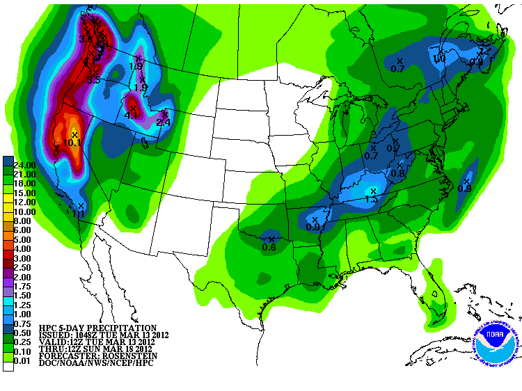
Sunday is looking to be windy with dust flying along the border.

The AQI forecast for today is showing more and more moderate areas for ozone in NM and other areas north.

Sunday, March 25, 2012

March 25 -

We saw above average temperatures and high clouds today thoughout the border region.  Several high temperature records were broken today.  The high at NMSU was 89F and the record was 87 recorded in 1971. Keep in mind that this will registered on March 26 since we take measurements at 7:30 am and officially the measurement will be taken tomorrow.

Today's AQI forecast was for good (green) air quality. We have been busy preparing for a measurement study in the Columbus/Palomas area to look at fugitive dust around the cattle holding facilities at the border. Below is a Google Earth map of the Palomas study sites. Most of the sites surround the cattle facility with one WSW of the town and two on the US site north of Palomas.
On Monday we will be installing the two E-BAM PM10 monitors and the PQ100 PM10 FRM. On Tuesday we plan on installing the Minivol PM10 samplers on power poles.

Tuesday, March 20, 2012

March 20 -

We had a cold start to the beginning of Spring with many stations more than 10 degrees below average. Below are this morning's observations at few NWS Cooperative weather stations.

                 Yesterday            Today
Station       High(F) Normal    Low(F)  Normal  Record Low Precip
Jornada         52      70       15      31        7 (1963) 0.00"
Antelope Wells  64      72       26      36       24 (2006) 0.15"
NMSU campus     50      71       27      38       25 (1965) 0.00"


Today's AQI forecast shows good air quality over the region and all of the southwest US.

Monday, March 19, 2012

March 19 -

Refreshing to see dust had settled out by the morning. There was even precipitation falling on the Organ Mountains this morning. Below is this morning's observations at few NWS Cooperative weather stations.

                 Yesterday            Today
Station       High(F) Normal    Low(F)  Normal  Record Low Precip
Jornada         69      71       36      30        2 (1963) 0.00"
Antelope Wells  64      72       35      35       23 (2000) 0.00"
NMSU campus     78      71       40      38       26 (1977) 0.00"


Today's AQI forecast shows moderate air quality over far west Texas and the Paso del Norte.
We will likely receive some precipitation from this storm but not a lot. This morning's QPF map shows most of it falling in the Bootheel region.
Looking out the window today, it looks like we received some precipitation this afternoon.  Based on the radar, most of the precipitation fell south of El Paso. The nmroads.com website showed that snow fell  briefly around Lordsburg but melted.


Sunday, March 18, 2012

March 18 -

Major dust storm - It started off innocent but by noon we're seen winds pick up. Now in the afternoon we're in a major dust storm today along the border.  So far NM Hwy 11 and 180 are closed going out of Deming. I-10 is still open but warnings are in place for low visibility in spots. Below is an image I took at 1:46 pm at corner of University and El Paseo. Visibility was estimated at 0.3 miles based on landmarks.
I was at the core site trailer earlier today and the PM10 BAM had stopped due to low flow rate. I changed the PM10 BAM max range from 1 mg/m3 to 10 mg/m3 hoping to see the maximum concentrations but it might even exceed 10 mg/m3 today.  At the time, the hourly PM2.5 BAM was reading 521 µg/m3. 

By late afternoon, the flow rate on the PM10 BAM didn't go up until the concentration went down below 1000 ug/m3. The PQ100 was flowing but unfortunately the Minivol didn't run. Below is the filter from the FRM PQ100 sampler. Before exposure the Teflon filters are white.

Below is a chart showing hourly PM10 collected at the NMED stations from today. The Las Cruces Holman Road station recorded the highest at 10,155 µg/m3.
Below is a photo of the PM10 BAM filter tape from samples taken on this day. Normally the spots are just noticeably brown and some days it is hard to tell if there is a sample. 


Saturday, March 17, 2012

March 17 -

I just got back from travel and now starting to catch up on things. It was a long drive to DRI Las Vegas and back since Thursday.  It was good to see my colleagues again.  Unfortunately I didn't have time to sightsee so just business. I now have six Minovol samplers (4 borrowed from DRI) to use in our dust study in Palomas, MX.  I also borrowed a Cahn microbalance for weighing the 47mm filters down to 1 µg. Now I just have to make room in my little lab to store all this stuff for a few days. That's not an easy chore.

I got back just in time to see the beginning our windy day along the border. At around 2 pm there was a large dust devil south of Deming as I drove by on I-10.  I didn't see any dust until I saw houses in Deming.  At around 3 pm I could see a large dust plume far south of Deming and probably was in Mexico. Using my polarized sunglasses I could make out the boundary of it south of Las Cruces as I crossed over from the west mesa near the I-10 rest area.

Looking at the GOES sounder long wave temperature differnce maps this afternoon, you can clearly see the  plumes going in the NE direction from the RAMSDIS webpage (see below).
The AQI forecast is showing moderate air quality over the Paso del Norte today due to PM10.
Tomorrow the forecast is showing the color orange or "unhealthy for sensitive groups."  Winds are forecasted to be in the 34 to 37 mph range with gusts to 60 mph. That will be enough for high levels of dust.

I just got done setting up the samplers in the dark.  I'll be collecting collocated 24-hour PM10 Teflon filter samplers at the core site trailer over the next few days. This will give us some comparison between Beta gauge PM10, FRM PM10 (BGI PQ100), and a Minivol with PM10 impactor. Now that I thought about it, I should have set the BAM measurement scale to read up to 10 milligrams/m3 when we get those strong dust storms.  I should also run the Dusttrak II too but I'll have to start that next week.

Wednesday, March 14, 2012

March 14 -

Happy Pi day.  Even though the allergies are starting up I'm still enjoying the balmy weather today. Below are a few of this morning's observations at NWS Cooperative weather stations in the region.

                 Yesterday            Today
Station       High(F) Normal    Low(F)  Normal  Record Low Precip
NMSU            80      70       38      37       23 (1988) 0.00"
Jornada         76      68       24      30       10 (1988) 0.00"
Antelope Wells  78      71       31      34       24 (2006) 0.00"


Based on EPA's AQI forecast we should be seeing good air quality along the border today.

Tuesday, March 13, 2012

March 13 -

Now that the storm track has moved north, we are enjoying a nice break of Spring weather along the border. Temperatures are running above the long term average and I'm not complaining. The 5-day QPF precipitation forecast map shows nothing this week.
The AQI forecast is showing moderate air quality in Dona Ana County due to ozone. This pattern seems be quite frequent when we have sunny skies and little wind.
Looking at the long term weather forecast for this weekend and the following week, the storm track looks to be moving back toward the south. Saturday is our best chance for winds and not sure yet how strong they will be.

Friday, March 9, 2012

March 9 -

We've cooled down considerable after the cold front rolled through the border region. Below is this morning's observations at few NWS Cooperative weather stations.

                 Yesterday            Today
Station       High(F) Normal    Low(F)  Normal  Record Low Precip
NMSU            59      69       28      35       15 (1964) 0.00"
Jornada         55      67       19      28        6 (1964) 0.00"
Antelope Wells  54      68       30      30       20 (1996) 0.00"

Based on the AQI forecast we should be seeing good air quality along the border today.

Thursday, March 8, 2012

March 8 -

We had a mixture of clouds, some transported dust, and a little isolated shower here and there today. As predicted, the upper level low is slowing moving through the region but not in the direction I want it to go. The models are showing is retrograding back west this weekend before it moves east. This will bring possible shower to the area on Saturday.

Today's AQI forecast showed an area of moderate air quality over Dona Ana County today due to ozone. There was some transported dust from the east impacting our area. It was hard to tell the source since cloud cover obscured the ground most of the day. I imagine that a significant amount was gypsum from White Sands although I can't prove it. This afternoon PM10 concentrations were in the range of 120 µg/m3 and PM2.5 about 25 µg/m3 near the NMSU campus.
On a side note we had a great El Paso/Las Cruces AMS chapter meeting tonight on campus. I was the speaker and I discussed my role as State Climatologist and my vision for bringing a flavor of atmospheric sciences to NMSU.  We decided to hold quarterly meetings and for now meet at a conference room in Skeen. 

I noticed from MSNBC that a section of I-25 in Albuquerque was closed today due to low visibility from dust.  The link is: http://usnews.msnbc.msn.com/_news/2012/03/08/10615518-new-mexico-dust-storm-shuts-down-i-25-delays-flights.


Wednesday, March 7, 2012

March 7 -

It's going to be a windy day along the border. The big question is how windy.  The National Weather Service is predicting "south southwest wind 20 to 23 mph increasing to between 38 and 41 mph. Winds could gust as high as 60 mph."  That was for Las Cruces and they are indicating slightly high winds for Deming and Columbus. This morning's 20km RUC winds are showing windspread high winds peaking in the early afternoon.
The NWS is also expecting possible road closures along I-10, south of I-10 and on the road to Silver City.

The AQI is taking the wind into consideration and telling us to expect unhealthy air quality today in the Paso del Norte and the rest of El Paso County.
10 am, I can see a brown cloud of dust to the west of Las Cruces moving east. 

10:33am Landsat 7 passed overhead giving us a detailed look at the dust plume.  The black stripes are part of the image since it has a scan problem on the satellite. Image courtesy of Max Bleiweiss and original image from USGS Glovis website.

The 10:55am pass of MODIS-Terra shows the dust plume right over Las Cruces. Image courtesy of NASA Lance website.

11:45 am: thick dust in Las Cruces with visibility less than a mile and decreasing

12:00 pm: highway 180 is closed from Hurley to Deming due to low visibility from dust. AQI at the Las Cruces west mesa station reach "Hazardous" level with hourly PM10 concentration of 690 µg/m3.

2:00 pm: I-10 is now CLOSED from Las Cruces to Lordsburg due to high winds, blowing dust w minimal visibility

2:30 pm: The following graphic from nmroads.com shows the closed highways (red highlight) in the border region.

4:30 pm:  I-10 CLOSURE EXTENDED Las Cruces to AZ State line. Blowing dust w minimal visibility.Avoid travels until conditions change


Monday, March 5, 2012

March 3-5

The weekend was nice and mild along the border but we're looking at another storm to march in Tuesday night and into Wednesday.

Today's AQI forecast shows moderate air quality due to ozone across all of Dona Ana county and parts of Otero.
More to come this afternoon as I look at the forecasts.

Friday, March 2, 2012

Mar. 1 and 2

March 1:
I was on the road in Santa Fe speaking at the Southwest Fire Ecology conference yesterday so I am catching up on things.  Before I discuss today's forecast here I'll give a brief summary of the conditions from yesterday. A shortwave trough and cold front moved through the state and caused high winds and blowing dust. As I was driving back from Santa Fe the strong southwesterly winds blew sand and dust across much of I-25. Hardest hit was in Valencia county that must have a lot of erodible land near the road (see photo below taken about 1:30pm).

March 2:
Today we will be expecting another wind day. At least here in Las Cruces the NWS forecast is calling for "Windy, with a west wind 21 to 24 mph increasing to between 29 and 32 mph. Winds could gust as high as 45 mph."

The AQI forecast is showing moderate air quality for the Paso del Norte, Dona Ana and parts of Otero county.