Monday, October 31, 2011

Oct. 31 - We have rebounded from the cooler airmass from a few days ago and back to above normal temperatures. Today the high at the airport was 75 degrees today.

   Yesterday           Today
High(F)  Normal     Low(F)  Normal
 76        73        40      39

Our monthly precipitation ended at 0.05 inches which brings us to 5.3 percent of normal for the month of October. November is typically a dry month with monthly precipitation only amounting to 0.46 inches on average. I will do a summary of the month for our station and other stations on Tuesday to assess where we are in totals across the southern desert region.

Tonight we saw a low wind, high PM event in the southern Dona Ana stations. Peak hourly PM10 at Sunland Park City Yard was 408 µg/m3.

Saturday, October 29, 2011

Oct. 29 - We're back to a warming trend and we climbed back to the 70s in parts of the region. Hachita topped out with a high of 72, El Paso and Animas reached a high of 71, and Deming peaked at 69. The high at the Las Cruces airport reached 68. Our low at NMSU remained the same as yesterday at 38 degrees. The low at Antelope Wells dipped down to 35 this morning. Below are the NMSU Cooperative observations taken today.

   Yesterday           Today
High(F)  Normal     Low(F)  Normal
 66        73        38       41

It's been a busy day so I'm not getting to posting until late. Based on a look at the end of the day at Airnow the AQI in the region remained in the good (green) category all day. The Anthony NMED station saw some realtively high PM this evening along with low winds. The interesting part is that the Sunland Park stations didn't see a low wind event which they tend to be similar but less intense in Anthony.

The map below shows areas without precipitation this month through today. The darkest red regions are those below 5 percent of normal. Most of southern Dona Ana., central Catron and the southern tip of Lea county are in this category. For example our 1981-2010 normal October precipitation at NMSU is 0.94 inches. So far we have measured 0.05 inches at the station this month giving us about 5.3% of normal precipitation.

Friday, October 28, 2011

Oct. 28 - It was a cool start to the day along the border with our low at NMSU 3 degrees below the long term average.
   Yesterday           Today
High(F)  Normal     Low(F)  Normal
 63        75        38       41

The low at the Las Cruces airport was 32F, 6 degrees cooler than in town. Deming's low was 34F and 40F at the El Paso airport. The forecasts are showing below normal temperatures for today but warming up again this weekend with highs in the 70s.  Looking at the sounding this morning at Santa Teresa we had a stable layer and temperature inversion all the way up to 650 mb or about 2.4 km above ground level. This should limit pollutant dispersal in the morning but the mixing height should increase slowly over the course of the day with our sunny skies.

The AQI forecast for areas along the US/MX border is green or good air quality. An area of moderate (yellow) is showing up in a portion of northwest New Mexico and along a line drawn from there toward Albuquerque. According to Airnow this is due to ozone.

Thursday, October 27, 2011

Oct. 27 - It was a nice some precipitation around the study area this morning as most CoCoRaHS observers measured at least a trace to a few hundredths of an inch from the storm yesterday. Maximum amounts in Deming were 0.22 inches and 0.17 inch in Las Cruces. The only snow reported in southern NM was in Cloudcroft with 2.3 inches at NM-OT-37.

The AQI forecast for today looks good air quality throughout the state of NM.

Wednesday, October 26, 2011

Oct. 26 - Sufficient moisture in the atmosphere might give a few areas some precipitation today.

Temperatures continue to be above average with this morning's low 9 degrees above the long term average.
   Yesterday           Today
High(F)  Normal     Low(F)  Normal
 83        75        51       42
Yesterday was warm but not enough for a record. The record high was 86 back in 1950.

AQI forecast shows a small area of moderate air quality in El Paso county for today due to PM10.
By the afternoon I can see a few patches of precipitation toward the west.
Snow is falling up in Taos. Below is an image from the Taos Ski Valley webcam today.
Some blowing dust can be seen at the Anthony station this afternoon. Winds are not high with gusts up to 8 m/s but looks like enough for dust with peak hourly PM10 of 137 µg/m3.
A couple of brief rain showers blew through Las Cruces at 7 and again at 8:20 pm tonight. Just enough rain to wet the sidewalks and not much more. Looks like a little rain in Deming as well. Below is a radar reflectivity map from College of Dupage at 6:05pm.

Tuesday, October 25, 2011

Oct. 25 - Based on the CoCoRaHS observers, most of southwest NM received at least a trace of precipitation last night. A few locations around Cloudcroft received more than a tenth and a couple observers in Deming recorded 0.07 inch.  Other than a few spots in Albuquerque it was dry across the state. However for the next 5-days it doesn't look promising for rain in southern NM. The 5-day QPF shows possible precipitation across northern NM but not in the southwest. Southeast NM looks to get some precipitatin in parts of Eddy and Lea county.
Temperatures remain above average with this morning's low 4 degrees above the long term average.
   Yesterday           Today
High(F)  Normal     Low(F)  Normal
 80        75        46       42

The AQI forecast for today shows good air quality for all of New Mexico.
Today was had our monthly Drought Monitoring Workgroup conference call. Not a lot of good news. The Four Corners is enjoying having NO drought according to the US Drought Monitor map. I haven't seen an extended white area in the maps for over a year. Meanwhile the south and southeast are still in status quo for drought activity. No rain is expected to dampen the drought enough but time will tell.
Some upper level moisture gave us plenty of contrails today from my office webcam this afternoon.

Monday, October 24, 2011

Oct. 24 - We're still in a period of above average temperatures for this time of year but that's about to change.
   Yesterday           Today
High(F)  Normal     Low(F)  Normal
 84        75        46       43

The upper level high that has been giving us nice weather has shifted slightly to our east and we're getting some moisture from the Pacific Ocean. We had some cloud cover today and the beautiful sunset.
I don't expect much precipitation from this plume of moisture and the QPF is showing a little to our north over the Gila Wilderness during the next 24-hours.
The AQI forecast for today shows a moderate air quality over the Dona Ana county. Peak AQI is 55 and is due to ozone.
Yesterday a low wind event occurred at the Sunland Park and  Anthony stations. At 5 pm peak hourly PM10 reached 310 µg./m3 while PM2.5 peaked at 24 µg/m3.

Saturday, October 22, 2011

Oct. 22 - I've enjoyed the warmer than average temperatures this weekend. Below are summaries at the NMSU Coop station as of today.

   Yesterday           Today
High(F)  Normal     Low(F)  Normal
 84        76        47       43

The AQI forecast for Sunday is for moderate (AQI of 67) in Dona Ana county. As in past days, this morning's surface inversion limited mixing close to the ground causing elevated PM at the Anthony and Sunland Park stations.

An interesting low wind high feature showed up at the Sunland Park City Yard station this evening as PM concentration levels were high coupled with low winds of 1 m/s.  Hourly PM10 at 7 pm peaked at 377 µg/m3 with PM2.5 at 76 µg/m3. At this point it doesn't appear to be an exceedance but nevertheless they are some high hourly values. This doesn't surprise me as the low wind events show up in October and last throughout the cooler seasons. Below is a depiction of the wind flow patterns and surface temperature at 6 pm today according to the 5-km RTMA model generated for 00 UTC. The curvy lines are wind streamlines showing winds at the surface. According to the model analysis the winds were from the north in Sunland Park at this time while the 10-meter winds at the station were from the south to south-southwest. The discrepancy shows the need for a detailed mesoscale model analysis beyond what is generated routinely from NOAA for general weather forecasting.

Friday, October 21, 2011

Oct. 21 - Continuing to warm up under the influence of a high pressure weather pattern. Yesterday's high at NMSU was 85, 8 degrees above the long term average. This morning's low was 44, just a degree below the long term average.

Today's AQI for the whole study area is for good air quality (green).
Particulates at the NMED Deming airport station were showing signs of pollutant build-up this morning as the winds were low and elevated PM10 (see plot below). The red line is the hourly averaged wind speed and the green line shows the hourly PM10 from the TEOM instrument. Yesterday's peak PM10 was likely caused by high winds.

Thursday, October 20, 2011

Oct. 20 - We're continuing to warm up after the cold front from a couple of days ago. This morning's low at NMSU was 44 which is right at the long term averge. Yesterday's high was 75, a degree below of the long term average.

The AQI forecast for today again shows the same moderate (yellow area) air quality as yesterday over Dona Ana county.
A fairly strong temperature inversion near the ground should cause pollutant concentrations to be elevated this morning (see bottom of the red curve).
Haze in Las Cruces was a little higher than usual. It's not clear what the cause is considering winds locally are low, humidity is low, and there are no fires in the region.

Wednesday, October 19, 2011

Oct. 19 - We should be on a warming trend as the afternoon should warm up to near or above normal temperatures. This morning's low at NMSU was 46F, 2 degrees above normal (normals High 76/Low 44). It felt cool but we're just used to the above normal temperatures. Yesterday's high was 74F, 3 degrees below our long term average.

The AQI forecast for today is indicating an area of moderate air quality in Dona Ana county due to ozone.
We'll be seeing southerly winds transporting airmasses from the south towards the north along the Mesilla Valley and eastsoutheasterly winds in areas in Luna, Grant and Hidalgo counties. Below is a forecast of surface winds at 18 UTC (noon) from the RUC model.
No precipitation is on the forecasted at least for the next 5 days.

Monday, October 17, 2011

Oct. 17 - A cold front is moving its way into eastern NM with strong winds and blowing dust. Looking at the Texas Tech webcams, all you can see is brown sky in the view, http://www.atmo.ttu.edu/webcams.html. The hourly PM2.5 concentration at 3 pm was showing 21.5 µg/m3. This should bring in cool air to our study region later in the day.

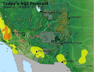
The AQI forecast for today shows an area of moderate air quality in southern New Mexico on around the Paso del Norte.
Last night I saw a moderate low wind episode at the southern NMED PM stations. The Sunland City Yard station recorded a peak PM10 concentration of 351 µg/m3 at 6 pm. PM2.5 was 61 µg/m3 at the time. We will probably expect to see more of them tomorrow morning as the ground cools and sets up a strong stable layer.

A haboob rushed through eastern NM in the afternoon bringing in low visibilities and thick dust. Below is a snapshot at 23UTC (5 pm) showing the dust cloud along an arc in the middle of the image. Vectors are from the 20-km RUC surface winds at 23 UTC.

Saturday, October 15, 2011

Oct. 15 -  We'll continue to be warmer than normal under this ridge of high pressure over the study area. Yesterday's high at NMSU was 88F shy of the record of 91 set back in 1996. Low at the Las Cruces airport was 52F at around 3 am and 47 on campus of NMSU. Our long term normal lows at NMSU and Deming for this day is 46F (right at the normal). Monthly precipitation at NMSU still stands at 0.05 inches.

The AQI forecast shows an area of moderate air quality in southern Dona Ana county and the Paso del Norte.

Monday, October 10, 2011

Oct. 10 - An upper level ridge moves in from the west and will warm our area. The past few days reminded us that it's October in case you have forgotten.

AQI forecast for our area shows all green and good air quality.
The morning sounding from Santa Teresa showed some nice stable air profile with low winds that could result in some locally elevated PM2.5 especially in the Paso del Norte. I've been trying to get on the NMED website to get concentrations but I've been unsuccessful.

Saturday, October 8, 2011

Oct. 8 - Cool morning but warmed up

I spent most of the day at City of Rocks State Park and it was very pleasant. It was the first time visiting that state park and I will probably visit again. Last night was a little cool with the winds but the campfire warmed things up. Winds were gusty and strong in some places on the drive from Las Cruces to Deming. However, I didn't see much dust. There were a few drops but not even a trace amount at the park. The morning low at Faywood (neareast Coop station) was 30F which made it a little cooler than I expected. The long term low temperature at Faywood for that day was 45F. Last time I looked on Friday afternoon, the forecast was showing more like lower 40s. But it shouldn't have surprised me since there was a freeze warning just north of that location. For reference the low in Las Cruces on the NMSU campus was 45F.

Based on a viewing of posts on Twitter, most of Northern NM received some sort of snow. In most of those locations it was the first snowfall of the year.

The AQI forecast for today was green over the whole state. Visibility was very good while I was at City of Rocks all of today.

Thursday, October 6, 2011

Oct. 6 - First regional dust day I've seen so far this time of year.  The forecast for today was wind gusts as high as 44 mph in the afternoon. Here in Las Cruces I first saw dust at around 1 pm looking out my west facing window in my office.  Hourly PM10 in Deming spiked to 400 µg/m3 at noon. Winds at the Las Cruces airport started to increase around 10 am and gusts in the 30 mph range by 11:30 am.  The AQI forecast shows moderate air quality due to elevated PM10 in West Texas and parts of southern Otero and Dona Ana counties.
This isn't a strong dust event and doesn't show up on the various long wave difference products but it does kick off our fall dust events.

Monday, October 3, 2011

Oct. 3 - A belated Happy Water Year!

The water year starts on October 1 and we're all hoping for an improvement in our drought here in southern New Mexico. Below is a summary of the past water year showing the change of drought levels since September 2010, the start of the past water year.
The precipitation forecast for the remaining calendar year 2011 doesn't show any significant relief.