Tuesday, May 31, 2011

May 31

Today southeast winds will bring in a moist airmass from the east.
As of this morning we can see the low level southeastern airmass' arrival from the Deming profiler starting around 12Z (6am MDT).
Based on the AQI forecast we should be seeing good air quality today.
So far the forecasts for precipitation are showing thunderstorms mainly over regions east of the Rio Grande. The 12Z QPF day 2 product for Wednesday morning through Thursday morning show a band of precipitation running along the border of the moist airmass in from Northern Chihuahua, El Paso, through Otero and Lincoln Counties. The lightest shade of green is 0 to 0.01 inches of precipitation.
We actually have some clouds in my cloud cam today

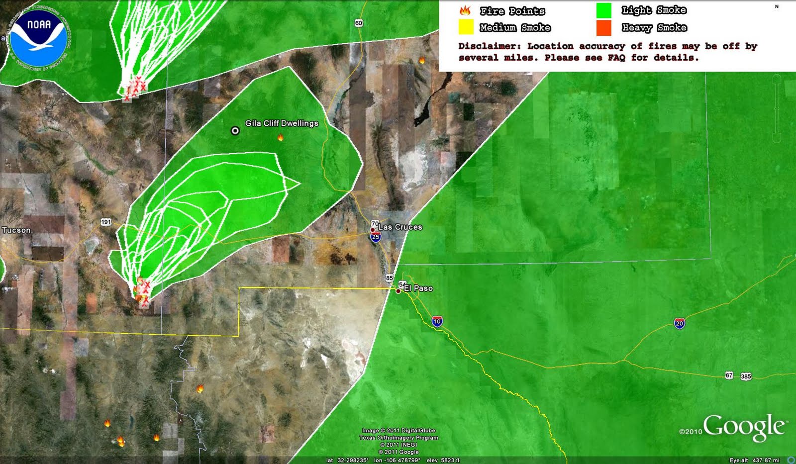
The HMS product shows the locations of the smoke plumes today. The analyst showed that the large blob of Mexican smoke has reached central New Mexico. See the large green area on the right in the map below.
At midnight, the moist airmass has finally arrived. That's pretty much what the GFS has predicted. From 12:30 to 12:45 am Wednesday morning dewpoint went from 45 to 51F and still climbing. The GOES IR image below shows the high clouds behind the moist boundary.

Monday, May 30, 2011

May 30

We'll see another breezy day. Highest winds could be over Chihuahua based on what the RUC model is showing. Below is the 6 pm wind forecast showing a streak of high southwesterly winds across Northern Chihuahua.
The AQI forecast indicates good air quality over the state.
We have a good chance of seeing thunderstorms on Tuesday late night and into Wednesday morning. I pulled the 06Z GFS this morning and it's showing a moisture surge crossing the Rio Grande by midnight and staying until the morning at least until 6 am. Below is the GFS dewpoint map at 850mb (roughly the surface) along with surface winds at 6 am on Wednesday morning. The model backs off this dryline back toward the east later in the day.
11:30am update: The 12Z GFS is also showing the dryline crossing across the Rio Grande late Tuesday. Below is a vertical profile of relative humidity at Las Cruces at 6 am on Wednesday.

Sunday, May 29, 2011

May 29

We saw high winds, windblown dust, and smoke plumes across the region today. Below was the RUC modeled southwesterly winds at 6 pm.
 
Southern New Mexico was covered with both dust and smoke plumes. At the end of the day the smoke plumes from the Horseshoe 2 Fire and fires in Chihuahua were blowing across the region.
Looking from space there was a lot of action today. First smoke plumes from the wildfires. Then there was the dust from the high winds. On top of that there was the smoke plume that was transported from Mexico into far southeast NM. Below the GOES visible image from NCAR from 7:15 pm shows all of those in one.
Based on a quick look at GOES animation the dust sources included a few hot spots in Chihuahua and White Sands. Other active dust sources included a few locations in the northeastern Arizona and northwestern NM. The NOAA GASP AOD product again proved to capture both dust and smoke plumes this afternoon.

Particulate concentrations were high due to the high winds at all sites in the study network. The Deming station hourly PM10 peaked at 377 µg/m3 at 2 pm. Hourly PM10 at the Sunland Park City Yard peaked at 1026 µg/m3 at 4pm.

Saturday, May 28, 2011

May 28

Much like other days it was a windy, hot, and dry day. High temperatures ranged from 100F in El Paso, 99 in Orogrande, 97 in Hachita, and 95 in Deming.  The big story is the likelihood of some precipitation next week. In the mean time we will see high winds on Sunday and Monday. Winds on Sunday could be high enough to loft windblown dust in our region.

The AQI forecast showed an area of moderate air quality in the Paso del Norte and El Paso County.

We saw a little more impacts from the Arizona wildfires today than yesterday. Winds in the afternoon were from the west southwest and it was hazy in Las Cruces. Below is a visible image from GOES at 7 pm.
The NOAA HMS product verified this as smoke plumes were driven by the westerly winds over most of the study region.
The NOAA GASP AOD product clearly showed the smoke plumes from the Arizona and Mexican fires at 6:15 pm MDT today.
The current NWS forecast shows a slight chance of precipitation over our area late Tuesday and into Wednesday morning.  Below is a map from the 00Z GFS run of surface dewpoints at midnight on Tuesday night. 
It shows the sharp dewpoint boundary moving over the Rio Grande Valley coming from the east. This dew point boundary of dry line will be item to track in future forecasts as it controls whether we will see precipitation or not. It looks highly probable that eastern NM will receive precipitation but it's still up in air if it'll reach us.

The 00Z QPF was not as generous but that might change in tomorrow's 12Z product.

Friday, May 27, 2011

May 27

I saw lots of lingering smoke this morning in Las Cruces. This morning I was at the Vado satellite station getting the ozone analyzer in working order. I could smell smoke while I was there. It smelled the same as when I was in Columbus yesterday.

From the NWS forecast, we are seeing westerly winds at or near 28 mph today with temperatures nearing the 100 mark. The high yesterday was 96F at NMSU. Today's low was only 60F. The winds may be an issue in blowing dust late this afternoon with gusts nearing 40 mph in some places.
 The AQI forecast shows an area of moderate air quality over the Paso del Norte and El Paso County from PM10.
Although outside of our study region, the outlook for precipitation over the next 5 days shows a possibility in eastern NM. Areas such as Carlsbad may see some thunderstorms on Tuesday. Carlsbad deserves some precipitation since their forecasted high temperature on Saturday might reach 108F.
As of 7 pm we have lots of smoke aloft in Las Cruces but not a lot at the ground. Below is the GOES visible at 7:15 pm showing the Horseshoe 2 Fire smoke plume drifting east. You can also see dust lofting off of White Sands and blowing northeast toward Tularosa.
By day's end the NOAA HMS smoke product showed the outlines of plumes over our study region. Push pins show ozone monitoring locations.

Thursday, May 26, 2011

May 26

The forecast is for a breezy day but I don't expect wildblown dust. The NWS forecast for Las Cruces is calling for winds in the 25 to 28 mph range with gusts to 39 mph. The RUC wind forecast below shows higher westerly to southwesterly winds to our north.
The forecasted highs today are going to be shy of the record but creeping up to it. Today's record at NMSU to beat is 99 F from 2006. There's not much relief from the heat and wind over the next few days. Southeastern NM and west Texas will peak at or around 100F today.

The AQI forecast for today again shows an area of moderate air quality over Dona Ana County and the Paso del Norte due to ozone.
The NOAA EMC ozone forecasts show a few hot spots of ozone this afternoon. The map below is their prediction at 6 pm today overlayed with the RUC wind vectors. The hot spot over in Otero County was a remnant of yesterday's high ozone and appears to be advecting toward the east.
The NOAA Smoke forecasts show continued smoke impacts from the Horseshoe 2 Fire in Arizona. Below is the surface smoke prediction for noon today. Smoke concentrations in communities such as Rodeo and Animas are likely to be high today.
I spend the afternoon and early evening in Columbus and saw lots of smoke from the Horseshoe 2 Fire. A large plume of smoke was carried east overhead but I could smell the smoke now and then. The photo below shows the view west at 7:30 pm in Columbus.

Wednesday, May 25, 2011

May 25

High temperatures today ranged from 89 in Animas, 88 in Hachita, 90 in El Paso, and 90 in Deming. It will continue to warm up tomorrow with the expected temperature the highest of the year. Winds were light today compared to the past few days. Below are the 6 pm forecasted winds from the RUC model.
Ozone was high across the region with the some hourly concentrations above at the Hurley station. Below is the AQI map at 12:20 am showing a regional ozone episode including two orange regions over the southwest US.
Today smoke from the two fires in our area could have impacted both ozone and fine particulates on the ground. According to the NOAA HMS product smoke plumes could be seen today across most of our region. The yellow push pins are the existing ozone monitoring stations that I commonly call the "backbone" network. The Hurley station is under the Miller Fire plume. However it's not clear if the plume reached the ground or just aloft.
The NOAA GASP aerosol product shows the Horseshoe 2 Fire plume drifting east in the afternoon.

Tuesday, May 24, 2011

May 24 - Dust alert day

Another windy day for our region. Highest winds are likely along the I-10 corridor as the RUC 6 pm forecast below shows. The NWS forecast indicates winds in the 18 to 25 mph range with gusts to 45 mph.
The AQI shows both moderate (yellow) air quality over Dona Ana County due to ozone and Unhealthy for Sensitive Groups (orange) over west Texas due to windblown dust PM10.
We saw high hourly PM10 at several sites due to windblown dust. Highest concentrations were observed at the Sunland Park City Yard (SPCY) and at the Las Cruces Holman Road station.

Monday, May 23, 2011

May 23

The forecast is for a windy Monday and Tuesday. The NWS is forecasting westerly winds in the range of 23 to 26 mph with gusts to 37 mph. The RUC is showing peak southwest winds in the late afternoon over the Bootheel, southern Grant, and west Luna counties.
This morning in Las Cruces I saw thin remnants of smoke plumes overhead.  My guess is it's from the Horseshoe 2 Fire in Arizona.

Today's AQI forecast indicated earlier orange (unhealthy for sensitive individuals) in West Texas but now it's showing the same area as moderate due to PM10 levels from wind blown dust.  I added the "wind blown dust" since they do not indicate the cause in the AQI webpage.
No change in precipitation forecast. No rain for the next 5 days. El Paso will exceed the maximum number consecutive days without precipitation but for Las Cruces we still have about 17 more days till we break the record.
By 7 pm smoke plumes can be seen in the distance drifting in from the west.
and from Las Cruces looking west about that same time.

Sunday, May 22, 2011

May 22

Today was a mild day with a few high clouds and mainly southwest winds. Below the RUC showed the highest winds south of the Bootheel and in Sierra County at 6 pm.
Looking at GOES imagery today, the winds aloft were from the southwest blowing smoke plumes toward the northeast. By 7 pm (see below) the smoke from the Horseshoe 2 Fire was very clear and can be seen covering an area across to the Sacramento Mountains and beyond.
The NWS is forecasting winds tomorrow in the 23 to 26 mph range with gusts up to 37 mph. Compared to past wind events, this doesn't look impressive. At this point I'm thinking more about isolated dust impacts rather than a regional event.

Saturday, May 21, 2011

May 21

Another breezy afternoon with highs in the low 80s across the region. A weak cold front passed over us this morning as the upper level trough over the midwest migrates east.
We had westerly and southwest winds most of the day. The RUC forecasts showed highest winds across northern Luna and southeast Grant county.
The westerly winds transported smoke from the Horseshoe 2 Fire toward Las Cruces but it seemed that most of the smoke was aloft and not that much reached the surface. The Santa Teresa sounding at 6 pm showed an inversion at 650 mb that probably kept smoke higher in the atmosphere. By this evening I saw smoke across the horizon and above Las Cruces but visibility was pretty good. Below is the NOAA HMS product at 10 pm.
The 5 day precipitation outlook is again dry.
The NMED Hurley 1-hour ozone concentration peaked at 75 ppb at 4pm with the 8-hour concentration was 72 ppb as of 9 pm. It is interesting since the Deming 1-hr max was 57 ppb at 2 pm. The NOAA/EPA ozone modeling doesn't capture this. Below are the 1-hour ozone concentrations at 4 pm from the NOAA EMC webpage. The concentration at Hurley was about 60 ppb in this model run.
The forecast for smoke on Sunday shows a possibility for some lingering smoke to drift into Dona Ana county in the morning. The map below is NOAA's surface smoke forecast for 9 am Sunday and isolated impacts of smoke.
Monday looks to be windy but still not convinced of a windspread dust event but it looks more like a day with isolated dust.