May 6
In Tucson today and drove back in the afternoon. I was too tired to post on Friday so I'm posting on the the 7th. Looking north along I-10 at Lordsburg I can see the Miller Fire plume in the distance. The smoke can be seen impacting the optical depth around noon today in the MODIS Terra AOD image below.
I also noticed a lot of dust devils starting around Bowie, AZ and through Lordsburg, NM. A few were pretty strong an moving a lot of dust.
May 7
Winds look to be from the southwest today. The NWS is showing winds in the 11 to 20 mph range in the afternoon.
Today's AQI forecast showed the usual area of moderate air quality centered over Dona Ana county due to ozone.
The Miller Fire is at 15,900 acres. The fire perimeter is shows expansion in all directions. The national monument is still open but probably not a good time to visit. I was planning on a visit but I'll postpone it a couple of weeks. By the end of the day we can see the wildfire activity for today in the image below. Clearly southwest flow aloft pushed the smoke plumes toward the northeast.The GOES GASP at 6:45 pm MDT shows AOD enhanced over these plumes although the cloud cover in southern NM masks a clear view.
Based on the Navy NAAPS model for today (18UTC), there is a complicated mixture of smoke from regional sources over our area. Based on their model the US is also blanketed with a plume of dust from coast to coast. I'm assuming this to be Asian dust based on the time of year and spatial extent over North America.
At night's end the humidity is very low, with dew point temperatures below zero F. That translates into RH in the single digits. No wonder why we have a lot of fires.
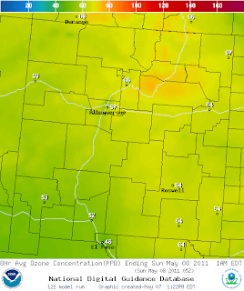
At 11 pm 8-hour ozone is in the 50s and 60s across NM according to the NOAA/EPA forecast model. Highest concentrations are in eastern part of the state and northern NM.


No comments:
Post a Comment