Thursday, May 24, 2012

May 24 -

Another hot and windy day. At least the smoke from the Gila fires are not impacting us as much as those areas north of here. Today we saw the smoke plume traveling eastward over the state. Below is a GOES image from 4:33 pm today.

I spent the entire day working at the Las Cruces dust control plots with folks from the Desert Research Institute.  I asked them to measure the erodibility of each of the test plots with their PI-SWERL wind erosion system. Shown below are George Nikolich (left) and Vic Etyemezian (right) operating their system on the untreated section.
We also help the DRI guys set up three "enhanced" BSNE samplers at another dust control site.

Wednesday, May 23, 2012

May 23 -

Smoke impacted more toward the east side of the state last night and early this morning.  I've seen Twitter reports of bad smoke in Artesia.

The big stories today are the continued smoke in the Gila and high winds in our region for the potential for blowing dust.

The AQI forecast for today shows an area of Unhealthy for Sensitive Groups (orange) over the Paso del Norte due to PM10. I am assuming that it is due to wind blown dust.

Today's BlueSky smoke predictions for PM2.5 show the highest impacts directly east of the Gila fires. I've also run Hysplit starting at 11 am and going through the next 24-hours. Both 500 m and 3 km trajectories align and head toward the northeast today.
Here is a view of the fire from MODIS on the Terra spacecraft. Image background was obtained from the NASA Lance website. The image is a mosaic from the 17:30 and 19:00 UTC satellite passes.

I read that the Baldy fire has grown to 11, 500 acres in the Gila Mountains. The smoke plume is clearly seen on GOES imagery this afternoon and flowing in an easterly direction.  With the high winds today, we have several opportunities to see dust and smoke. Looking at the 23:32 UTC GOES image, I picked out locations of blowing dust.  The Gila wildfire plume is very dense and extends across New Mexico and into Texas.


Tuesday, May 22, 2012

May 22 -

Another warm, sunny, and breezy day for the borderlands.  Last I checked at 1pm it was 93 degrees.  The big question is how much wind we are going to get over the next couple of days. According to the National Weather Service, the winds tomorrow afternoon are forecasted to be in the 31 to 34 mph range with gusts to 50 mph.

10 am update: I haven't seen much smoke impacts here in Las Cruces although it was a little hazy this morning. I did a quick run of Hysplit starting this morning at 5 am and over the following 24-hours. The plot below shows the trajectories for 500 m (green) and 3 km (red) above the ground according to the 12Z NAM wind fields.
Update 3:30 pm:  Based on the visible GOES satellite loop, I'm seeing some wind shear moving some of the plume toward the east-southeast which is a little different than the Hysplit predictions. That shift in direction could bring some of the smoke south along the Rio Grande River valley.  The afternoon (21z) NOAA HMS smoke outline product is showing widespread smoke over the area.

Today Elizabeth Smith and I set up a weather station to monitor conditions at the second dust control site. This site is located at the Diamond Springs#5 subdivision off of Roadrunner Parkway. We installed a Davis Vantage Pro in a backyard facing the test plots. This station logs weather data every 5-minutes to a datalogger inside the house.
Update 4:45 pm:  I ran Hysplit in ensemble mode using 20km Rapid Refresh model wind fields from 21Z (2 pm) and the plume from the Baldy fire is more closely aligned with the outline from the GOES visible loops.  Green lines are 500m forward trajectories and red is 3km. Based on this I would expect to see impacts from the smoke plume in Dona Ana and Otero Counties over the next 24-hours.
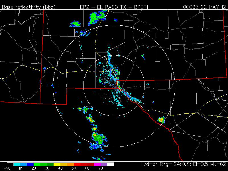
Smoke plume covers the horizon in Las Cruces looking west to north but remains high. It also shows up clearly on the EPZ radar.
Too bad I don't have the ceilometer here. It's still running in Reno but hope to borrow it again. Based on the echo tops from the EPZ radar, the top of the plume reaches 30,000 (9.1 km) to 35,000 feet (10.7 km). Below is the echo top product at 00:51Z.
At 6:58 pm the smoke is over Las Cruces and still high with not much reaching the surface. Below is a photo from campus looking northwest.


Monday, May 21, 2012

May 21 -

A warm day but not a record.  Today's high at the NMSU Coop was 95F as of 6 pm tonight.  Thunderstorms popped up early in the day over the Sacramento Mountains and by 6 pm, we were feeling the outflow winds in Las Cruces.  The NWS had issued several severe weather warnings in Otero County and West Texas.

I set out a petri dish to collect fungi suspended in the air from the outflow winds.  The highest winds at the station was 19 mph from the east during the sampling.  The site is sort of sheltered on campus and obviously it was much higher outside of town. Below is a reflectivity map from the radar showing the line of dust and a few droplets from the outflow (courtesy of College of Dupage).
Wind trajectories for the wildfires in the Gila are pushing smoke toward the northeast and east today. The green lines are forward trajectories from 500 meters and the red ones are from 3 km.  Hysplit was run in an ensemble mode to mimic spatial uncertainty. There is a trajectory every 6 hours starting from 5 am this morning.
Winds are expected to increase this week and unlikely to give firefighters a break in controlling the fires here in NM and AZ. The moisture is feeding thunderstorms and could produce lightning over the next couple of days.
 

Friday, May 18, 2012

May 18 -

We've been seeing the effects of several wildfires on our area. Last night's Naval Aerosols model run showed the complexity of the pollutant airmasses over our area. The map on the lower left shows the surface smoke concentrations from their model for 5 pm last night.
The impacts to our area are small and take a little work to find them but they are there. Earlier this week we saw long range transport from Asian fires that stayed high in the troposphere and didn't reach the ground. I did a Hysplit run at 10 km and sort of matched the smoke plume pattern. Later this week we are starting to see more continental wildfire smoke both from south of us and from the region.  Albuquerque has been expecting more from the regional fires in central Arizona and less here along the border. The City of Albuquerque has been sending out notices to this effect.  Compared to last year, we are seeing less fire activity up to this point. Last year we were seeing fires such as the Miller fire in the Gila and the Horseshoe II fire in SE Arizona.

The NOAA HMS smoke plume product by the end of the day shows the extent of the smoke across the US but little over the border region. A small plume reaches across the Gila and smoke sits across much of eastern NM.

The AQI forecast shows good air quality over the border region today.

Saturday, May 12, 2012

May 12 -

Sunny skies with slighly below seasonal temperatures described the weather today. Reports of severe thunderstorms over Sierra County were reported by the NWS this afternoon. There was also a thunderstorm with possible hail west of Orogrande and moving toward the southeast based on the Special Weather Statement tonight.

I saw that ozone has reached over 70 ppb in Sunland Park today.  Peak hourly averaged ozone at the City Yard station was 74 ppb at 3 pm.

I saw a distant smoke plume while in Silver City today during sunset. I'm not sure what fire was causing this smoke plume.
The NOAA HMS smoke product was showing a nearby plume from a fire in the Gila as well as one in Arizona. The green shades represent smoke plume outlines as determined from satellite.


Thursday, May 10, 2012

May 10 -

Yesterday brought more rain and the forecast again shows for continued rain along the border today.  Below shows this morning's multi-sensor derived precipitation across southern NM for the past 24-hours.
CoCoRaHS observers in Las Cruces measured amounts from 0.20 to 1.50 inches. The areas south of Deming also received rain.

 Below are this morning's observations at few NWS Cooperative weather stations.
                 Yesterday            Today
Station       High(F) Normal    Low(F)  Normal  Record Low Precip
Antelope Wells  69      86       48      48       38 (1995) 0.08"
NMSU campus     69      86       52      51       38 (1965) 0.19"

The rain from the past two days have helped out a lot in the precipitation deficit in southern NM. Below shows a map of percent of normal rain for the past 30 days.Anywhere you see blues to purples, that is more than 150 percent of normal.  At least for Las Cruces our 30 year average rain for May is 0.38 inches and as of today we have 0.39 at the NMSU weather station and some locations in town have close to 2 inches.This is normally our dry season so we can't complain.
As the storm spins away toward the east, where do we stand with precipitation today in Las Cruces?  If it doesn't rain again the whole month in Las Cruces, May 2012 will be the 25th wettest May on record. This is based on the precipitation measured at the NWS Coop station on campus.  May of 1992 was the wettest with 2.03 inches. On the other dry end of the data, 28 out of the last 121 years had no rain in May. Recall last year we had no rain in May.

Not surprising the AQI forecast is showing good air quality across the region.


Wednesday, May 9, 2012

May 9 -

We're in a very moist airmass with this morning's sounding at EPZ showing relative humidity nearly 70 percent up to 350 hPa (8.3 km MSL).  Rainfall amounts in Las Cruces ranged from 0.35 to 1.06 inches as the map below shows.

Below are this morning's observations at few NWS Cooperative weather stations.
                 Yesterday            Today
Station       High(F) Normal    Low(F)  Normal  Record Low Precip
Antelope Wells  80      85       48      50       38 (1995) 0.00"
NMSU campus     76      85       52      50       33 (1965) 0.40"

As a comparison at the NMSU campus station, a CoCoRaHS gauge recorded 0.39 and the Climate Center tipping bucket read 0.38 inches. All these measurements are located within 10 feet of each other.  At the NMSU Leyendecker Ag Science Center we recorded 0.6" in the Climate Center tipping bucket and a nearby CoCoRaHS gauge registered 0.72".

Today's AQI forecast shows good air quality over the region and all of the southwest US.

The forecast is for continued shower activity over the border area with some heavy rain at times.

Tuesday, May 8, 2012

May 8 -

From bone dry to Severe thunderstorms. Today broke our 81 day dry streak for no rain. Most of the border region across eastern Luna and Dona Ana counties received rain this afternoon. There was a report of golf ball size hail in Caballo and the ground in Hatch was covered in small pea sized hail.
 Below shows the nice display of mammatus clouds after the storm in Las Cruces.

Tuesday, May 1, 2012

May 1 -

As part of air quality awareness week, today is World Asthma Day. I found out the hard way that it is also Labor Day in Mexico (Día del Trabajo). I needed to get an equipment carnet signed today so I could bring some instruments back home but they were not at work. I guess it'll wait till tomorrow.

Airnow is showing another good air quality day along the border. The only area in NM with moderate levels are in the Four Corners as the AQI forecast map shows below.
Skies were clear along the border and some light winds in the afternoon. Below is a view from Palomas looking north with the border wall hugging the horizon.
 I saw many dust devils all afternoon with some fairly large and making their way through town.