Showing posts with label High wind event. Show all posts

Monday, March 28, 2016

March 23, 2016 dust episode

Following the March 22 high wind day, the next day proved to be a potent dust day along the border.

Based on a summary of maximum wind gusts from the National Weather Service this event was similar in strength.


Dust source areas (pink color in map) in southwest New Mexico and Mexico showed up in today's 1:44pm MDT VIIRS dust product image from NASA SPoRT.
Some of the same dust source areas on the previous day were also emitting today. However on this day the wind direction was from the northwest pushing dust toward the southeast.

March 22, 2016 dust event

A strong synoptic dust storm impacted most of the border country on March 22 and 23. High winds started early on the 22nd across the region and peaked late in the afternoon.

Traffic cameras along I-10 recorded times of near-zero visibility in the afternoon. The cameras west of Lordsburg showed episodes of blowing dust from the playa or dry lakebed.  At the peak of the dust storm at about 4:11 am MDT the mile marker 11 camera (view toward the west) looked like this.
A few minutes later at 4:14 pm visibility increased a little but still a dangerous situation
The National Weather Service summarized the peak wind gusts and part of that statement is shown below. Click on it to view it. Peak winds at the Lordsburg playa were recorded at 61 mph at 4:49 pm/ In Deming winds gusted to 46 mph at 5:13 pm.
From satellite the dust could be seen from sources in New Mexico, Arizona, and Mexico. Below is an animated GIF of dust plumes as seen from NOAA GOES satellite of this afternoon.


Saturday, March 12, 2016

March 12, 2016 Forecasted dust

An upper level low travels through the border region today and is expected to bring in high winds. The National Weather Service is forecasting blowing dust starting around 11 am MST on Saturday. The graphical weather forecast is shown below for 11am MST
As of 9 am MST the forecasted winds in Las Cruces, NM were"Windy, with a west wind 16 to 26 mph increasing to 28 to 38 mph in the afternoon. Winds could gust as high as 55 mph." The soils along the border are likely very dry so the forecast of blowing dust appears appropriate.

Post event analysis

By 12:50 pm MST, dust sources in Chihuahua were active and dust plumes could be seen moving toward the ENE direction south of El Paso. Below is an image from NASA's VIIRS dust product that I obtained from their SPoRT webpage. In this product, dust shows up as bright pink. I brought the image into Google Earth and added the text.
By 3:30 pm MST, I could clearly (at least from my eyes) see dust plumes across Luna and Dona Ana Counties. One particular dust source west of Hatch was one that it unusual. Below is an image that I created based on 4-km GOES infrared channel 4 and highlighted the dust in light red over a tan background. The red over the mountains was clouds and not dust. The inset image is from Google Earth and shows what the landcover looks like near the dust source area.

A few dust plumes appeared on the DOT cameras operating on I-10 in Hidalgo county. I was monitoring the mile marker 11 and 12 cameras on Saturday and plumes appeared to be the typical "here one moment, gone the next" types. Here are a couple that I grabbed from nmroads.com website.


Thursday, July 9, 2015

Our group has been monitoring the dust west of Lordsburg on interstate 10 near the playa. Our remote cameras have been showing a few dust events that reminds me to be cautious when driving over that kind of landcover. I posted a clip from June 9 of this year on YouTube to show much of a problem that area is to motorists. What is troubling is the length of time that the dust obscured the road. In this case it lasted about 7 minutes. The view looks east along the highway and is approximately the same area as the May 2014 accident that took lives.

Wednesday, July 8, 2015

July 7, 2015

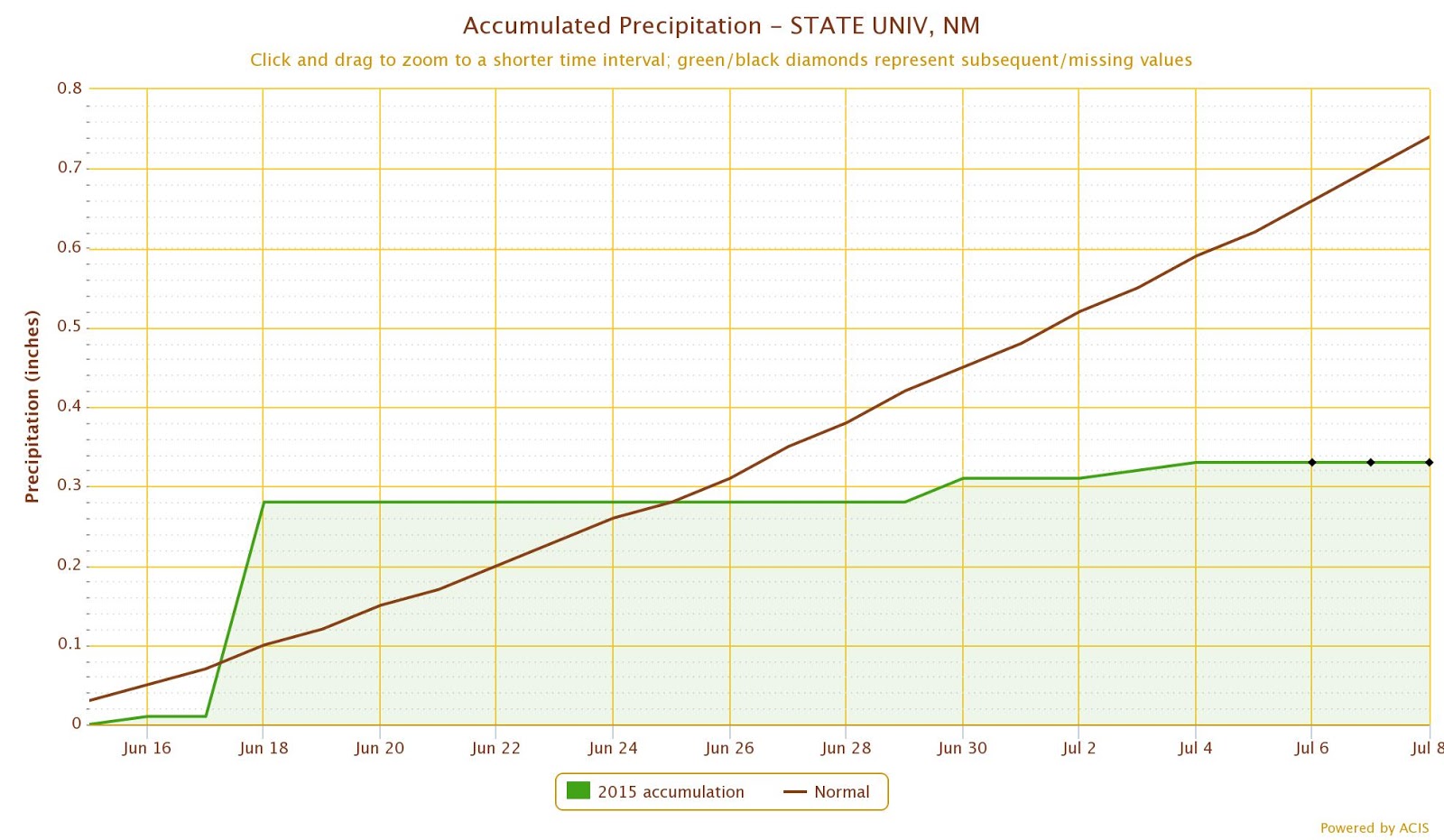
So far the monsoon precipitation has been above average for most of the state of New Mexico but below average in a few places in southern part of the state. The monsoon "season" officially started in June 15 and at Las Cruces station at NMSU recorded 0.33 inches of precipitation. This is in comparison to the long term average of 0.74 inches.
With this precipitation deficit, we are bound to see dry soils and dust when thunderstorms blow through the area. Today was one of those cases and we saw brief but high winds during thunderstorms in the afternoon. I took the photo below at 3:51 pm standing on the Las Cruces dam vista.
This was caused by a thunderstorm outflow and can easily be seen in the weather radar. I highlighted the outflow boundary in yellow and the arrow shows the direction of movement.


Wednesday, May 13, 2015

Tuesday, May 12 was full of weather action along the border. Along the east side of the region from Deming to Sacramento Mountains, we saw heavy rain and brief wind gusts. Along the west side near Lordsburg I noticed blowing dust near I-10.

I captured multiple images from the NM DOT cams at nmroads.com and created a brief animation. The first one is from mile marker 12 on interstate 10.
The second animation is from mile marker 11.


Sunday, May 10, 2015

May 9, 2015

Despite above average precipitation in 2015 through most of New Mexico including the southwest part of the state, the soils are becoming dry west of Lordsburg at the playa. Over the winter most of the playa has been covered in water but over time it has been evaporating. During the spring we have seen dust from synoptic storms as well as from convective dry microbursts. On May 4th most of the dust at the playa was from dry microbursts that generated high winds. These winds were short lived but intense based on the traffic cams installed near the highway. A few days later on May 8th winds were elevated from a passing cold front at the same location. I've captured a few screen shots of the NM DOT cameras installed at mile marker 11 to show how the dust looks from the overpass at that location. I have similar animations from the cam at mile marker 12 but I'll show just the ones at mile marker 11 here.

May 4th dust events from mile marker 11. This camera looks west along I-10. Each frame of the animation is about 1 or 2 minutes apart. Notice the complete brown-out later in the animation.
May 8th dust events from the mile marker 11 camera.
When driving through scenes like these, please be very cautious and observe the rules of Pull aside, turn off lights, foot off the brake, and wait it out. The Arizona DOT has a very informative website for this.

Tuesday, November 11, 2014

Nov. 10 - Haboob moved through northeastern New Mexico today along with a cold airmass

The animated sequence of satellite images below shows the path of the dust coming out of southeast Colorado and entering Union County, NM.

Visibility at the Clayton airport dipped to 4 miles at 6:55pm due to the dust while the winds were blowing 33 mph from the north with gusts to 44 mph. Dramatic changes in temperature also were observed in that area. At Clayton the temperature at 2:55pm was 77F and by 6:55pm it was at the freezing point, for a drop of 45F over a 4 hour period.

Wednesday, April 30, 2014

April 30 - Dust storm Irina brings in haze to the border area today

Yesterday high winds lofted dust from the Texas Panhandle as seen from satellite. Below is an image from the VIIRS SPoRT dust product. The pink area clearly identifies the dust that was generated from the storm.
Winds overnight transported some of this dust from the Panhandle to much of New Mexico and the border region. This morning's dust over Las Cruces was transported across west Texas and up toward the Panhandle overnight as the Hysplit plot below shows.
At 8am this morning haze has blanketed Las Cruces and remains in the air through the afternoon. The photo below is looking east toward the Organ Mountains from Las Cruces.
I expect the dust to linger even with a modest wind today.  The plot below shows Hysplit backtrajectories from various locations in the NM and AZ for 3pm this afternoon will continue to bring in haze.
As of noon a dust source in Chihuahua that looks to be east of the NM Bootheel is emitting dust. Winds are transporting it in a west northwest direction. Below is a GOES sounder longwave difference image at 12:02pm with the dust showing up in deep red and purple.
By 1pm the Mexican/Bootheel dust plume traveled into Arizona's Chiricahua Mountains and probably impacting I-10. Below is the VIIRS dust product from SPoRT at 1:41pm MDT.
As of 3pm the haze lingers in southern NM but cleared up slightly probably due to daytime mixing and deeper mixed layer. Below is a shot from San Augustine Pass at 2:30pm looking toward the Sacramento Mountains and Tularosa Basin to the east.


Monday, April 28, 2014

April 28 - Dust storm 'Helen' event summary

A particularly deep upper level trough has caused a couple of exceptional dust events to the border region this past weekend.

Below is a longwave difference animation that I recorded from the RAMSDIS webpage that shows the dust this morning looping around the low. Areas of dust show up as the deep red to violet.

The dust source area also shows up on the VIIRS dust product from SPoRT.  This was image was captured at 3pm mountain time.

Wednesday, June 5, 2013

June 4 - Another thunderstorm outflow haboob

Around 8 pm another haboob rolled through Las Cruces bringing in thick dust just after sunset. The photo below is from 8:39 pm looking south from Highrange.

Monday, June 3, 2013

June 3 -

Yesterday's (Sunday) haboob that blew through Las Cruces was spectacular in that I didn't really expect a distinct wall of dust. I was watching the radar echoes of the outflow boundary around 6:30 pm and noticing it move northward. The photo below was snapped at 6:57 pm as it crossed over A-Mountain and the southern part of Las Cruces.
We've uploaded to YouTube a time lapse of the haboob from the same location but looking directly south. YouTube timelapse. This haboob is not a spectacular as the ones in Phoenix but it's the most dramatic I've seen in Las Cruces. The video is a little shaky since I had to hold down the tripod during the high winds to keep it from blowing away. The surface weather map at 00 UTC (6 pm) showed winds from the south and high dewpoints to our east.
 The haboob showed up very clear on the weather radar and you can watch for yourself the progress of it by clicking on the animation below. The haboob boundary shows up as the string-like line moving from the south toward the north through the animation.
 
As a bonus, I show a plot of lidar backscatter from our ceilometer located just west of the NMSU campus. The plot shows that the leading edge of the haboob extends to about 700 meters above the ground. As expected the highest backscatter levels and likely highest particle concentrations are near to the ground. Impacts of the haboob also continued for more than 3 hours but the most dense part lasted about an hour.

Wednesday, April 17, 2013

April 17 - What a day along the border! Not just another dust storm but one that lasted more than 12 hours.

At 9 am: Winds are forecasted in Las Cruces area to be in the 31 to 41 mph range in the afternoon with gusts up to 55 mph. The time series plot below is based on the 13-km resolution Rapid Refresh model at a grid cell in Las Cruces for wind speed today. Winds should peak at 23 UTC.
 Below is a color shaded wind speed forecast for 22 UTC today.
As of 7pm, this dust storm is a whopper. I-10 has been close since noon and the winds and dust plumes have not let up. Below a NMDOT truck blocks the entrance to the frontage road that runs along I-10 near the Las Cruces Airport. A State Police cruiser blocked the entrance to I-10. I talked to the NMDOT worker who was directing traffic here and he said that there are locations down the road that have zero visibility. He also mentioned he exchanged words with some disgruntled travelers from 'back east' who didn't understand the dangers of driving along this stretch of highway. State Police had ultimate say on when the road will open up.
Hundreds of trucks and cars line both I-10 and side-roads as they wait for the interstate to open.
Below is another videocast of today's dust storm as seen from GOES, courtesy of NCAR RAP webpage.
 
Another look at the storm from the GOES sounder longwave difference product provides some more information. As I mention in the videocast, a distinct New Mexico hot spot is clear in the looping images.
Below is a view southwestward from the Las Cruces Airport at 5 pm. As I expected this area is not a likely source area for the dust. A few construction areas on the way to the airport were causing some localized dust but not a lot.
A quick look at surface particulate matter concentrations shows very high concentrations of PM10 in Deming in the afternoon. Peak hourly PM10 nearly hit 3000 ug/m3 at 1 pm and again at 4 pm .
Below are the PM10 concentrations measured at the Las Cruces West Mesa station today. Peak PM10 was nearly 3000 ug/m3 this afternoon.What is interesting is that the dust started to increase about the same time as in Deming, with Deming reaching the peak earlier.
We installed the CL31 ceilometer on top of the monitoring trailer so we'll be showing some products from that soon. I just received the unit on Monday after being used in a year-long project in Sparks, NV for investigating high PM2.5 exceedances. I glanced at the backscatter profiles at around 6:30 pm and it was showing most of the dust confined to a layer about 800 meters thick. As expected the highest levels were near the ground.

By the end of the day, particulate concentrations decreased to pre-storm levels. Below is a summary of hourly PM10 across the New Mexico monitoring stations. The Las Cruces Holman station recorded the highest hourly value of 3977 ug/m3. The 24-hour average PM10 at that location was 557 ug/m3, which is about 3.7 times the EPA standard.
Peak hourly PM2.5 were nearly 200 ug/m3 across all stations in southern NM.  Highest 24-hour averaged PM2.5 was at the Sunland Park Desert View Elementary School station with a 90 ug/m3 concentration.


Tuesday, April 16, 2013

April 16 - another dusty afternoon

As seen in the annotated image below we saw more dust out of the Four Corners region and some activity in the southwest border region.


Monday, April 15, 2013

April 15, 2013 - Tax day dust

As expected, dust was flying somewhere in the border region on tax day. It seems to be the tradition. It looked like the highest dust concentrations were observed in far southern Dona Ana County this morning. I looked at the Sunland Park city yard station and the concentrations were around 500 ug/m3 at 9 am.

Here is an annotated briefing of dust around the state based on GOES images from the NCAR RAP website. Turn your speakers on for this one as I am describing the locations of the plumes.

Friday, March 8, 2013

March 8, 2013

Dust storm in the afternoon today. Our NMSU webcam showed the dust arriving on campus around 4 pm today. Peak PM10 was 1560 ug/m3 at 5 pm and stayed near 1000 through 7 pm. PM2.5 was over 100 ug/m3 over the same three hours. Below is a view from our Skeen Hall webcam through 9 pm tonight.


Saturday, February 9, 2013

Feb. 9 - Dust storm

The conditions were right for another dust storm over the border region today. Based on a reports from the National Weather Service here are a few peak wind gusts in each county affected: In Dona Ana County at San Augustin Pass 75 mph, 71 mph in North El Paso, 41 mph at the Redrock RAWS in Grant County, 46 mph at a station near Rodeo in Hidalgo County, 53 mph at the Deming airport, 60 mph near Sunspot, and 70 mph on Salinas Peak on WSMR in Sierra County. This storm was well forecasted since early in the week and the NWS mentioned dust early in the forecasts. The photo was snapped at 12:43 pm and shows the level of haze over Las Cruces. Normally you could see the top of the Hotel Encanto from this view at 2.24 km but the haze totally obscured it.
Around the region dust concentrations were very high. Below shows hourly PM10 collected at the Deming airport station operated by NMED. Peak hourly PM10 was 1863 ug/m3 at 10 am.
Hourly PM10 at the Anthony Elementary School peaked at 3265 ug/m3 at noon today.  Hourly PM2.5 was 221 ug/m3 at the same time.

The morning MODIS image onboard the Terra satellite showed very distinct dust plumes from areas in Chihuahua and White Sands. There was also evidence for some dust coming off of areas in northeastern Luna County as well. I saw this source in Luna County emitting at the last dust storm.
Supporting our project's emphasis on bioaerosols we collected samples during this event from a 6-stage cascade impactor. Using this sampler we investigate the fungal content of the dust in six size ranges.
We also measured a peak aerosol optical depth of 0.38 at 530 nm wavelength just after 1:30 pm  this afternoon. This was measured using a single band sun photometer that we built. This was the highest AOD measured this year. This matches the GOES AOD product for this afternoon.


Friday, April 27, 2012

April 26 -

Another blowing dust day along the border

The GOES visible image below shows the widespread dust plumes from today's winds. Image is courtesy of NCAR's Real Time Weather page.
I flew in from Lubbock today and wasn't looking forward to the flight to El Paso, but it wasn't that bad by the time I landed around 9 pm.  Sky was hazy and still windy but the worst had passed through the region earlier.

Peak AQI today reflects the high winds and blowing dust observed in our area.
By the way the American Lung Association published their annual rankings of worst and best air quality and Las Cruces failed in the short term particulate category.  I did two interviews (KRWG and Sun News) on this topic and will post links to those.


Saturday, April 14, 2012

April 14 -

Another major dust event along the border. It is miserable in Las Cruces and started in the morning but visibility is dipping in the early afternoon. By 12:30 the visibility is down to 1 mile or less. The AQI forecast is not telling the whole story this day. The air quality is bad in the Paso del Norte but also across the region.
The 11 am reading of PM10 at the NMED West Mesa station was 2311 µg/m3, in the hazardous AQI category. The station also had 53 mph wind gusts during that hour.  With air quality like it is, it is best to stay at home and limit your outside exposure as much as possible.

The visibility is about 0.75 miles based on this image taken at 1 pm today from my porch on the east side of Las Cruces.
I also see that highways 11 (Deming to Columbus) and 180  (Deming to Silver City) are closed due to blowing dust limiting visibility. There are also warning signs on I-10 west of Las Cruces to the Arizona border due to high winds.

Sunday, March 18, 2012

March 18 -

Major dust storm - It started off innocent but by noon we're seen winds pick up. Now in the afternoon we're in a major dust storm today along the border.  So far NM Hwy 11 and 180 are closed going out of Deming. I-10 is still open but warnings are in place for low visibility in spots. Below is an image I took at 1:46 pm at corner of University and El Paseo. Visibility was estimated at 0.3 miles based on landmarks.
I was at the core site trailer earlier today and the PM10 BAM had stopped due to low flow rate. I changed the PM10 BAM max range from 1 mg/m3 to 10 mg/m3 hoping to see the maximum concentrations but it might even exceed 10 mg/m3 today.  At the time, the hourly PM2.5 BAM was reading 521 µg/m3. 

By late afternoon, the flow rate on the PM10 BAM didn't go up until the concentration went down below 1000 ug/m3. The PQ100 was flowing but unfortunately the Minivol didn't run. Below is the filter from the FRM PQ100 sampler. Before exposure the Teflon filters are white.

Below is a chart showing hourly PM10 collected at the NMED stations from today. The Las Cruces Holman Road station recorded the highest at 10,155 µg/m3.
Below is a photo of the PM10 BAM filter tape from samples taken on this day. Normally the spots are just noticeably brown and some days it is hard to tell if there is a sample.