Showing posts with label dust. Show all posts

Monday, March 28, 2016

March 23, 2016 dust episode

Following the March 22 high wind day, the next day proved to be a potent dust day along the border.

Based on a summary of maximum wind gusts from the National Weather Service this event was similar in strength.


Dust source areas (pink color in map) in southwest New Mexico and Mexico showed up in today's 1:44pm MDT VIIRS dust product image from NASA SPoRT.
Some of the same dust source areas on the previous day were also emitting today. However on this day the wind direction was from the northwest pushing dust toward the southeast.

March 22, 2016 dust event

A strong synoptic dust storm impacted most of the border country on March 22 and 23. High winds started early on the 22nd across the region and peaked late in the afternoon.

Traffic cameras along I-10 recorded times of near-zero visibility in the afternoon. The cameras west of Lordsburg showed episodes of blowing dust from the playa or dry lakebed.  At the peak of the dust storm at about 4:11 am MDT the mile marker 11 camera (view toward the west) looked like this.
A few minutes later at 4:14 pm visibility increased a little but still a dangerous situation
The National Weather Service summarized the peak wind gusts and part of that statement is shown below. Click on it to view it. Peak winds at the Lordsburg playa were recorded at 61 mph at 4:49 pm/ In Deming winds gusted to 46 mph at 5:13 pm.
From satellite the dust could be seen from sources in New Mexico, Arizona, and Mexico. Below is an animated GIF of dust plumes as seen from NOAA GOES satellite of this afternoon.


Saturday, March 12, 2016

March 12, 2016 Forecasted dust

An upper level low travels through the border region today and is expected to bring in high winds. The National Weather Service is forecasting blowing dust starting around 11 am MST on Saturday. The graphical weather forecast is shown below for 11am MST
As of 9 am MST the forecasted winds in Las Cruces, NM were"Windy, with a west wind 16 to 26 mph increasing to 28 to 38 mph in the afternoon. Winds could gust as high as 55 mph." The soils along the border are likely very dry so the forecast of blowing dust appears appropriate.

Post event analysis

By 12:50 pm MST, dust sources in Chihuahua were active and dust plumes could be seen moving toward the ENE direction south of El Paso. Below is an image from NASA's VIIRS dust product that I obtained from their SPoRT webpage. In this product, dust shows up as bright pink. I brought the image into Google Earth and added the text.
By 3:30 pm MST, I could clearly (at least from my eyes) see dust plumes across Luna and Dona Ana Counties. One particular dust source west of Hatch was one that it unusual. Below is an image that I created based on 4-km GOES infrared channel 4 and highlighted the dust in light red over a tan background. The red over the mountains was clouds and not dust. The inset image is from Google Earth and shows what the landcover looks like near the dust source area.

A few dust plumes appeared on the DOT cameras operating on I-10 in Hidalgo county. I was monitoring the mile marker 11 and 12 cameras on Saturday and plumes appeared to be the typical "here one moment, gone the next" types. Here are a couple that I grabbed from nmroads.com website.


Thursday, July 9, 2015

Our group has been monitoring the dust west of Lordsburg on interstate 10 near the playa. Our remote cameras have been showing a few dust events that reminds me to be cautious when driving over that kind of landcover. I posted a clip from June 9 of this year on YouTube to show much of a problem that area is to motorists. What is troubling is the length of time that the dust obscured the road. In this case it lasted about 7 minutes. The view looks east along the highway and is approximately the same area as the May 2014 accident that took lives.

Wednesday, July 8, 2015

July 7, 2015

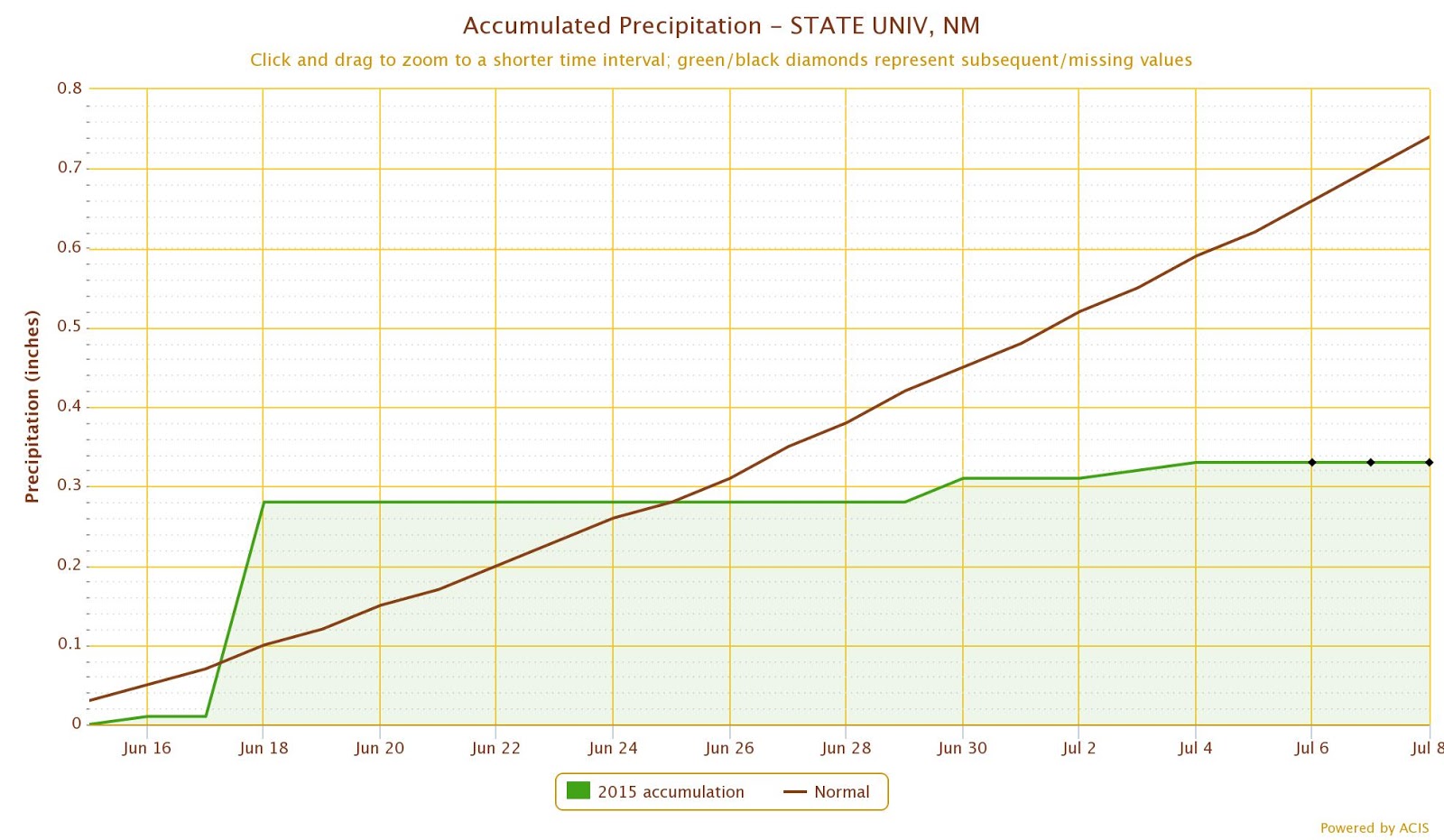
So far the monsoon precipitation has been above average for most of the state of New Mexico but below average in a few places in southern part of the state. The monsoon "season" officially started in June 15 and at Las Cruces station at NMSU recorded 0.33 inches of precipitation. This is in comparison to the long term average of 0.74 inches.
With this precipitation deficit, we are bound to see dry soils and dust when thunderstorms blow through the area. Today was one of those cases and we saw brief but high winds during thunderstorms in the afternoon. I took the photo below at 3:51 pm standing on the Las Cruces dam vista.
This was caused by a thunderstorm outflow and can easily be seen in the weather radar. I highlighted the outflow boundary in yellow and the arrow shows the direction of movement.


Wednesday, May 13, 2015

Tuesday, May 12 was full of weather action along the border. Along the east side of the region from Deming to Sacramento Mountains, we saw heavy rain and brief wind gusts. Along the west side near Lordsburg I noticed blowing dust near I-10.

I captured multiple images from the NM DOT cams at nmroads.com and created a brief animation. The first one is from mile marker 12 on interstate 10.
The second animation is from mile marker 11.


Sunday, May 10, 2015

May 9, 2015

Despite above average precipitation in 2015 through most of New Mexico including the southwest part of the state, the soils are becoming dry west of Lordsburg at the playa. Over the winter most of the playa has been covered in water but over time it has been evaporating. During the spring we have seen dust from synoptic storms as well as from convective dry microbursts. On May 4th most of the dust at the playa was from dry microbursts that generated high winds. These winds were short lived but intense based on the traffic cams installed near the highway. A few days later on May 8th winds were elevated from a passing cold front at the same location. I've captured a few screen shots of the NM DOT cameras installed at mile marker 11 to show how the dust looks from the overpass at that location. I have similar animations from the cam at mile marker 12 but I'll show just the ones at mile marker 11 here.

May 4th dust events from mile marker 11. This camera looks west along I-10. Each frame of the animation is about 1 or 2 minutes apart. Notice the complete brown-out later in the animation.
May 8th dust events from the mile marker 11 camera.
When driving through scenes like these, please be very cautious and observe the rules of Pull aside, turn off lights, foot off the brake, and wait it out. The Arizona DOT has a very informative website for this.