Monday, June 27, 2011

June 27

Another sweltering day. We saw a high of 106 at the NMSU Coop station and at the Las Cruces Airport.

Today's AQI forecast predicted an area of unhealthy for sensitive individuals across Dona Ana and parts of Luna county.

Dewpoint temperaturs are hovering between 28 and 32F today. The afternoon spawned a few thunderstorms but so far I have only seen virga. The image below shows the convective cells and resulting 0.5 degree reflectivity at 7 pm this evening.

Sunday, June 26, 2011

June 26

Today's high was 105.8 or rounded to 106. The record for today was a blazing 109 set back in 1994. Our minimum this morning was 73. The long term averages for today are low 65 and high 97. The winds based on the 18Z RUC showed WNW directions in the north part of our region.
The day started off clear but by the afternoon clouds developed over the state. The AQI forecast for today predicted moderate (yellow) air quality over most of Dona Ana and Unhealthy for sensitive groups (orange) over El Paso county.
The Albuquerque radar showed virga over central NM and the path of the Las Conchas wildfire smoke plume. Below is a snapshot at 7 pm from GOES. An image loop of GOES imagery showing the Las Conchas plume has been posted to YouTube. And a view from a webcam north of Santa Fe shows the plume in detail today.

Saturday, June 25, 2011

June 21-24 summary
I have been at the Air & Waste Management Association's annual meeting this week and now getting caught up with the blog summaries. The meeting was in Orlando, Florida and brought in professionals from all over the world to present papers, posters, panels, and workshops in topics including air and water pollution, regulations, solid waste, and pollution control. There were a lot less attending compared to when I used to go regularly 10 or so years ago. Probably the cost of travel has a lot to do with it.

Ozone over these four days showed one day at the Desert View site with peak 1-hour at 85 ppb on the 22nd.
The Chaparral site ozone was at 75 ppb on the 22nd and 23rd.
In Las Cruces the peak hourly ozone was 69 ppb on the 22nd.


June 21

The AQI forecast for today was showing an area of moderate air quality over south-central NM due to ozone.
The AQI due just to smoke impacts includes all of southwestern NM in an area of moderate air quality.
A view of the Guadalupe Mountains this afternoon looking north. The haze just got worse as the plane traveled east toward my connecting flight in Austin.


June 22

The smoke impacts AQI map shows an improvement in southwest NM today.

June 23

Today's high was 104.

Smoke impacts are continuing to improve and the AQI smoke map will not be updated unless significantly smoke impacts are predicted.
At my last evening of the conference was treated to a nice rain shower and thunderstorm. I can see why they call Florida the overall leader in the number of lightning strikes. These innocent clouds in the pic below made quite a show a few hours later. The view is from the 22 acre lake at the Coronado Springs Resort in Orlando.


June 24

It was a hot one with our high temperature of 105F. Today's high was just shy of the daily record of 106 from back in 1978.

Flying back from the conference there was some haze over west Texas this afternoon but not as bad as earlier in the week. The pic below is of the Guadalupe Mountains looking north from around 30,000 feet.

Monday, June 20, 2011

June 20

Moderate air quality is expected today in southwest New Mexico.
Winds were mainly out of the westnorthwest near the surface based on the Deming profiler this morning.

Sunday, June 19, 2011

June 19

Fires are still active but smoke in our region is less than last week. The smoke impacts forecast for today anticipates moderate (yellow AQI) air quality in SW New Mexico.
A bigger story in our region is going to be the winds today and resulting blowing dust. The National Weather Service is forecasting west southwest winds between 28 and 33 mph, with gusts as high as 47 mph. The 15Z RUC is showing winds strongest over the center of our region, along I-10. Below are wind predictions at 6 pm MDT.
The Deming profiler is showing high winds aloft that look to mix down as our day progresses.
The Horseshoe2 Fire remains the biggest source of smoke in our region based on the number of acres burning and its proximity. As of this morning is has burned 210,331 acres and is 75% contained. Yesterday 3,997 acres were burned. Trajectory colors are 500 (green), 1500 (blue), and 4000 (red) meters above the ground. The trajectories start at 15 UTC (9 am MDT) and are shown every 3 hours till tomorrow morning at 6 am. Fire locations are from the NOAA HMS product at 11:30 am today. The smoke product shows a little plume SE of Deming at the foot of the Little Florida Mtns. Not sure what that is since the fire detection doesn't pick it up. My window looks out toward that direction and I don't see anything at noon. The trajectories from the Monument fire run a similar path so depending on the amount of smoke and dispersion we'll get impacts from both. We will also get smoke from the Hachita Fire located just west of Hachita on both sides of highway 9.


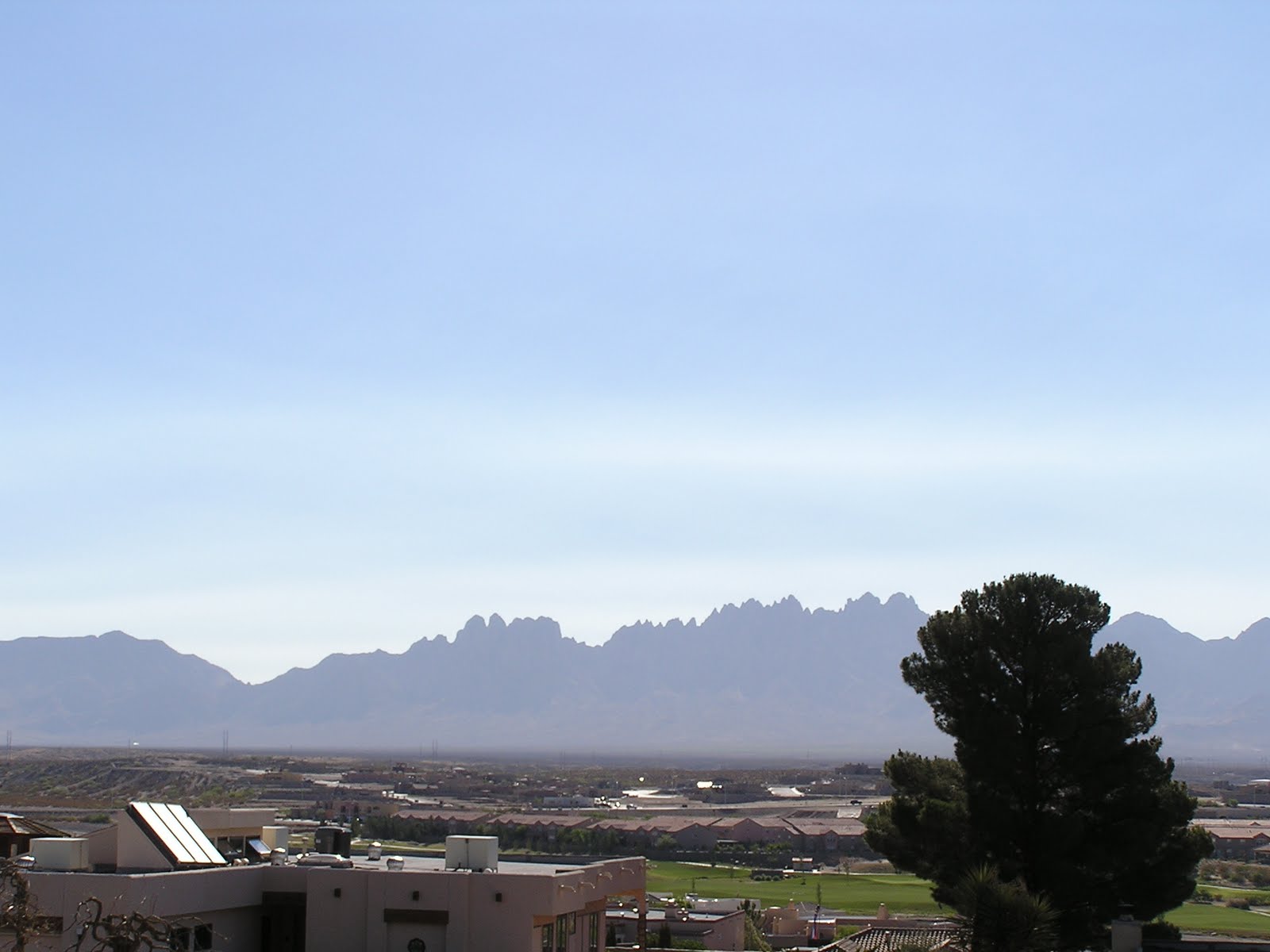
At 1:15 pm haze is starting to increase looking out toward the west. At 5 pm the haze was dense with blowing dust. The pic below was looking southwest from the Highrange Neighborhood.
Thick haze from both smoke and dust later in the afternoon around 6 pm. The haze had a slight blue hue. Strong smell of smoke at 7 pm tonight. Below are the HMS smoke and fire products at 8:53 pm. Notice the red shading or thick smoke over Luna county.
At 10:30 pm some ash was falling down on campus. You can see a couple in the image below as sort of a gray smudge.
The last of my Teflon filter samples was taken today. I collected four polycarbonate filter samples of soot tonight to look at under the campus scanning electron microscope. I took two 10 minute and one 20 minute sample. I think I got enough sample since the filters smelled like a campfire as I was putting them into their petri slide protectors. I had hoped to collect some dust samples but the PQ100 sampler pump couldn't take the pressure drop from the 0.4 micron pore size nuclepore filters. Instead I used an external diaphram pump that was heftier. I still used the PQ100 filter holder, WINS PM2.5 impactor, and the PM10 inlet. I'll check the flow rate tomorrow.
The ceilometer was picking some of this up too. I'll wait till tomorrow morning to download the data. 

Saturday, June 18, 2011

June 18

Air quality impacts from the fires in Arizona were predicted to be in the moderate AQI range today. Blowing dust in isolated locations will potentially degrade this.
This morning light haze filled the skies in Las Cruces with light winds. Winds at the Deming radar wind profiler showed westerly and west-southwest winds throughout the day.

A nice milky pink sunset at 8:11 pm. Pichacho Peak is to the left of the image.
Samplers are ready for the dust tomorrow. Below we have the MiniVol and a PQ167 below that. These are collocated with the DustTrak II, a CL31 ceilometer, meteorological station, and the NWS Cooperative Observer site.

June 17

The air quality from smoke is improving as we continually see fires but not as intense as last week.  However, air quality near the fires will remain a concern as night time smoke drainage down from higher to lower elevations will be an issue. These are difficult to forecast since it depends on the terrain and low level wind patterns. I saw some haze this morning in Las Cruces but not that much more than we usually get. We had some cloud cover that masked some of the smoke today. Below is the NOAA HMS smoke product with fire locations as of 10:26 pm tonight. The Monument fire remains active and burning near Sierra Vista, Arizona. The plume has mixed in with the smoke from the Horseshoe2 to add to the haze.
We saw mostly WNW winds from the surface through 5 km up till this afternoon. Aloft winds are back to southwest in the evening but surface still WNW.
The air quality outlook includes a forecast of winds for this weekend. It will be windy again on Saturday but on Sunday we could see wind blown dust as our major pollutant. However, the winds will also produce more fire activity and probably more smoke in the Monument and Horseshoe2 fires. Temperatures are expected to be in the 100 to 103 range in the lower elevation desert on Saturday and Sunday.

Saturday's smoke outlook shows our area with moderate air quality.
I have not seen any relief in the form of rain at least for the next week. The QPF product shows continued dry over the next 5 days.


Thursday, June 16, 2011

June 16

Air Quality Alert for Thursday. This includes southwest New Mexico near the Wallow and Horseshoe2 Fires.

Due to the continuing smoke from the Horseshoe 2 Fire it is expected that the air quality in southwest New Mexico will continue to be in the unhealthy for sensitive groups range (orange AQI) on Thursday. We might see less smoke in the eastern parts of the study area but if the fire remains active, areas close to the burning will be impacted more.

Afternoon winds look to be an issue this afternoon for fire danger as well as for some blowing dust in areas with highly erodible soils. Below are RUC forecasted winds at 6 pm.

There was a little haze this morning in Las Cruces. I smelled smoke and saw some elevated smoke layers. The photo below was snapped at 8:37am looking at the Organ Mountains.
Hysplit predictions from the Horseshoe2 fire show the west-southwest flow carrying the smoke across Hidalgo, southern Grant and Luna counties today. Trajectory colors are 500 (green), 1500 (blue), and 4000 (red) meters above the ground. The trajectories start at 15 UTC (9 am MDT) and are shown every 3 hours till tomorrow morning at 6 am. Fire locations are from the NOAA HMS product at 10:30 am today.The map below shows a view looking down on the Horseshoe2 Fire toward the east.

Wednesday, June 15, 2011

June 15

Air Quality Alert for Wednesday. Please read the Air Quality Alert that includes SW New Mexico.


Due to smoke from the Horseshoe 2 Fire it is expected that the air quality in far southwest New Mexico will continue to be in the unhealthy/very unhealthy/hazardous range on Wednesday. 
 
Particulate concentrations collected in Las Cruces yesterday and this morning are much lower than yesterday. The graph below shows PM2.5 from the past 24-hours.


Winds from the Deming profiler shows northwesterly winds with a change in direction from the northeast between 9 and 10 am this morning. Winds aloft remain westerly.


Today's wind pattern forecast shows southwest winds in the Bootheel and northwest in the lowlands above I-10. Below is the RUC foreacst for 6 pm today.


I'm looking at the next four days (Thu-Fri-Sat-Sun) for wind to affect fire activity and wind blown dust along the border. Below is the 12Z run of the 80-km GFS surface wind forecast at Lordsburg.


 Smoke started to settle in Las Cruces around 7 pm tonight. I snapped this photo at 8:39pm.
At 7pm GOES shows the smoke plume drifting east northeast with significant horizontal dispersion. The green vectors are from the 00Z NAM run at 700mb and the blue shows KEPZ reflectivity. A significant amount of smoke came in from the Monument Fire along the Arizona/Mexico border south of the Horseshoe2 plume.
The moon rise over the Organ Mtns tonight was impressive.


Tuesday, June 14, 2011

June 14

Air Quality Alert for Tuesday. Please read the Air Quality Alert that includes SW New Mexico.


Due to smoke from the Horseshoe 2 Fire it is expected that the air quality in southwest New Mexico will continue to be in the unhealthy for sensitive groups range (orange AQI) on Monday. The map below shows a predicted area of air quality categorized as "unhealthy for sensitive groups" along the border from the El Paso to the Arizona state line.
This morning the winds from the Deming profiler are showing northwesterly winds near the surface and westerly aloft.
A view of Organ Mountains this morning at 7:50 am shows some low level haze and an inversion "lid" at about 1.9 km MSL.
There was an error in the last few plots of DustTrak PM2.5 and I've made the corrections to the plots from previous days. A plot of the last 24-hours of PM2.5 is shown below. PM2.5 at NMSU showed a sharp increase at 9 pm last night and continued high till the after the sun was up.
Forecasts from the Horeshoe2 Fire show trajectories going directly east and east southeast across our study region. Trajectory colors are 500 (green), 1500 (blue), and 4000 (red) meters above the ground. The trajectories start at 15 UTC (9 am MDT) and are shown every 3 hours till tomorrow morning at 6 am. Fire locations are from the NOAA HMS product at 11 am today.
Data from the Lordsburg satellite site was downloaded on this visit and I checked on the general operation. Everything looked good. The Horseshoe2 smoke is in the background.
I also delivered a DustTrakII to monitor smoke southwest of Lordsburg in what I think will be a hotspot for smoke. I will likely leave the monitor there for the next week or so to collect smoke concentrations near the fire. Glenda Mahan at the extension office in Lordsburg agreed to email the data each morning over the next week. During my visit the Horseshoe2 Fire plume was not impacting Lordsburg or Deming in the afternoon. However, it looked like places like Animas, Columbus, and areas along the border were in the plume. The map below shows a view from MODIS aboard Aqua at 1:50 pm MDT. In Lordsburg I could see the Wallow smoke plume to the north. I noticed a little pyrocumulus building up in the late afternoon.
Not too long after the Aqua satellite's overhead passage, I snapped a view of the Horseshoe2 plume east of Deming on I-10 at 2:30 pm.  The Florida Mountains are in the background. It looked as if most of the plume was south of the mountains from my viewpoint. It was breezy in this area and there were some dust plumes scattered around.
The updated alert graphic for tomorrow shows a worsening of air quality due to the Horseshoe2 smoke. The areas of highest impact includes locales south of I-10 from just east of the fire to the Dona Ana County line.