Monday, April 30, 2012

April 30 -

This is National Air Quality Awareness week. To know more about this NOAA and EPA have more information pages.

The AQI forecast for today shows good air quality over the border region.
I was at WSMR most of today giving two presentations and noticed haze in the Tularosa Basin. It was particularly noticeable as I passed over St. Augustine Pass and had a good view of the valley.   Looking at the Naval Research Laboratory aerosol prediction system, there might be a good amount of smoke flowing in from our neighbors to the south. If you look at the bottom right map in the image below you can see a plume of smoke clipping the eastern side of NM.
NOAA also produces a smoke concentration forecast product that I show below from 10 am this morning. It's possible some of the smoke predicted on the east corner of the state made its way into the Tularosa Basin, causing some haze.


Friday, April 27, 2012

April 27

Breezy conditions have stirred up some dust in the afternoon but not much. The AQI forecast for today showed good air quality over all of New Mexico.

April 26 -

Another blowing dust day along the border

The GOES visible image below shows the widespread dust plumes from today's winds. Image is courtesy of NCAR's Real Time Weather page.
I flew in from Lubbock today and wasn't looking forward to the flight to El Paso, but it wasn't that bad by the time I landed around 9 pm.  Sky was hazy and still windy but the worst had passed through the region earlier.

Peak AQI today reflects the high winds and blowing dust observed in our area.
By the way the American Lung Association published their annual rankings of worst and best air quality and Las Cruces failed in the short term particulate category.  I did two interviews (KRWG and Sun News) on this topic and will post links to those.


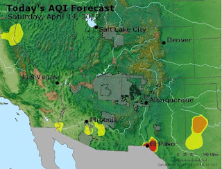
Saturday, April 14, 2012

April 14 -

Another major dust event along the border. It is miserable in Las Cruces and started in the morning but visibility is dipping in the early afternoon. By 12:30 the visibility is down to 1 mile or less. The AQI forecast is not telling the whole story this day. The air quality is bad in the Paso del Norte but also across the region.
The 11 am reading of PM10 at the NMED West Mesa station was 2311 µg/m3, in the hazardous AQI category. The station also had 53 mph wind gusts during that hour.  With air quality like it is, it is best to stay at home and limit your outside exposure as much as possible.

The visibility is about 0.75 miles based on this image taken at 1 pm today from my porch on the east side of Las Cruces.
I also see that highways 11 (Deming to Columbus) and 180  (Deming to Silver City) are closed due to blowing dust limiting visibility. There are also warning signs on I-10 west of Las Cruces to the Arizona border due to high winds.

Friday, April 13, 2012

April 13 -

So far the big story is the wind and blowing dust forecast for today and Saturday.

The AQI forecast for today shows an area of moderate across the Paso del Norte but green elsewhere.
The AQI in the Paso del Norte for Saturday is  "Unhealthy" or red color for the Paso del Norte due to PM10 from blowing dust. Contrary to this Airnow is showing good air quality in Dona Ana County.

I tried to get the third E-BAM started to be used at Pancho Villa State Park but it looks like pump is shot. It'll probably take at least a week to get a replacement from MetOne.

Wednesday, April 11, 2012

April 11 -

We did not receive much precipitation along the border from the past storm except for a few isolated patches. The storm cells tended to favor the Chihuahua, southeast corner of Dona Ana County and most of El Paso County. Below is the radar derived precipitation for the past 24-hours from the National Weather Service AHPS database.
 Last night I was looking south and hoping for turn toward the northeast but that was not to be. Here is a short time lapse fro 11:45 pm to 12:23 am looking south from Las Cruces. I could see a few rain columns and captured a few lightning bolts.
There was a brief spike in PM10 at the Sunland Park City Yard due to the thunderstorm but it was only for one hour. PM10 peaked at 111 µg/m3 at 11 pm last night.

We are not expecting any precipitation from the next round of storms as the forecast shows just winds. Below is the precipitation forecast for the next 5 days from the NOAA QPF webpage.

Monday, April 9, 2012

April 9 -

Even though it was brief and very isolated it was nice to see a little precipitation fall in the study area. A couple of the CoCoRaHS observers in Santa Teresa saw a nice amount of rain last night. One observer measured a whopping 0.80 inches and a neighbor not too far away measured 0.47 inches.  To precipitation fell in Las Cruces.  Below is the radar derived amounts as of this morning. Base on this trace it looked like it was just one cell that provided our rain.

The AQI forecast for today shows good air quality across all of New Mexico.

Monday, April 2, 2012

April 2 -

A significant cool air mass has settled over the border region. Highs in the 60 are forecasted over the area as the upper level low slowly creeps toward the east.

The AQI forecast shows an area of moderate over Dona Ana, southwest Otero counties due to ozone. The portion in west Texas is attributed to dust as PM10.  The orange colored area over Lubbock is due to wind blown dust that is forecasted for today.
We will again miss out on any precipitation from upper lows passing through the region.The map below shows the 5-day QPF with precipitation falling well north of us in the mountains near Raton.
The winds and dry conditions are causing the border region to be included in a fire weather area today.
Winds have increased this afternoon with gusts up to 46 mph at 3:15 pm at the Las Cruces airport. Some blowing dust can be seen across Las Cruces and has caused some haze but overall visibility remains good.