Thursday, March 31, 2011

March 31 - Breezy morning, sunny, and warm day at the Border. We end another month with no measurable precipitation in most of the region. Sunday looks to be favorable for windblown dust.

The AQI forecast for today is showing good air quality over the whole state.

A few fires were active in our region today. Smoke from these may have some noticeable impact. Below are fires and smoke plume outlines from the NOAA HMS product with RUC surface winds at 00 UTC (6 pm MDT) shown on top. Overall the plumes match the wind flows at that hour. We've been getting both surface and aloft winds from the northwest most of the day.

I brought in the Aqua MODIS AOD measurement with the fire locations and it looks like the smoke occurred later in the afternoon than the Aqua spacecraft overpass due to lack of correlation with AOD. The higher AOD area to the west of Elephant Butte is interesting since I have been often seeing higher values there.

Our next dust event is shaping up for Sunday afternoon. The NWS is forecasting winds in the range of 38 to 41 mph with gusts to 55 mph.

Wednesday, March 30, 2011

March 30 -
We are at beginning of the upper level ridge and the northwest winds that come with that. As of 11 am we are seeing surface winds from the NW at most of the western NM stations.

A low pressure trough moves its way across from the northwest to create some winds on our western area. Here is the 00 UTC (6 pm) wind forecast from the RUC model (15Z run).

Today's AQI forecast shows good air quality in our region.

Tuesday, March 29, 2011

March 29 - Starting the warming trend and light winds today

Looking at the forecasts, I'm seeing a broad upper level ridge remaining over our area until Sunday. This means nice warm days, very dry conditions, some breezy afternoons, and still mornings with inversions that could cause pollutant build-up in the Paso del Norte. We might see ozone starting to pick up at a few locations. The dry conditions also are a concern for wildfires. During this type of airmass we can see dewpoint temperatures drop and relative humidity dip down less than 10 percent. Recently, during one of these dry periods, I saw a RH of about 1 percent. A weak trough is affecting us today and tonight with backdoor cold front creeping in from the east.

Late morning today we should be seeing northerly winds with the strongest in Sierra county
Later in the day we're back to light winds from the west.

The AQI forecast shows good air quality in our region today with an area of moderate in north-central NM.

We saw the return of the evening low wind, high PM at the Sunland Park City Yard station tonight.
A similar situation at the Anthony Elementary with a low wind spike in the evening.

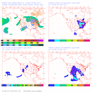
It is spring and we are starting to see the signs of biomass burning from Mexico and Central America. Actually the fires have been going on for over a month but the transport of the smoke has only been obvious since the past few weeks. I again turn to the Naval Aerosol model to look at what they predict in terms of smoke at the surface and aloft. The bottom right plot shows surface smoke concentrations across North America. If we do see impacts the particles are solely in the fine particle fraction with sizes less than 1 micron and typically much less. I expect small impacts in our region but it's all part of the overall haze we see. In southern Texas they are well acquainted with this type of smoke aerosol and sometimes gets intense.

Looking at the models for the rest of this week, I don't see any opportunities for high winds. The next chance could be at the end of this weekend, possibly on Sunday afternoon and maybe Monday.

Again no sign of measurable precipitation for our region over the next week. Us along with southern AZ and west TX continue to dry out. I saw a note from my colleagues in the west coast saying California is having its 3rd wettest March with statewide average snowpack at 168 percent of the April average. Just to add to that, Squaw Valley (8200 feet) has reported 241 inches of snowfall for the month of March 2011 with 265 inches snow depth on Monday. Alpine Meadows reported a snow depth of 315 inches on Saturday March 26 which settled to 304 inches 48 hours later.

Monday, March 28, 2011

March 28 - A windy day is on course but not a lot of dust expected. Some localized windblown dust from erodible areas is to be expected.

Below is the 15UTC run of the 20kmRUC model showing surface winds at 21 UTC (3 pm MDT). It looks similar to last night's prediction so I expect again that the highest winds are to be north of I-10 and mainly over northern Luna and Dona Ana counties.

Over all the NMED sites in the region today we saw three sites with hourly averaged PM10 over 150 µg/m3 in response to the wind. Those were at Anthony, Sunland Park City Yard, and Las Cruces Holman Road.

Today's AQI forecast from the EPA is green across all of NM

Sunday, March 27, 2011

March 27 - Expecting a breezy week especially Monday and Wednesday afternoons.

This afternoon's MODIS AOD is spotty so not a lot of information but shows low aerosol over western NM.

Today's AQI forecast shows good air quality over the Land of Enchantment.

The NMED air quality data website is not providing data so no plots today.

The outlook for tomorrow is definitely for some winds. The main question is how strong and will dust be an issue. The 00Z-12kmNAM model output shows peak winds at around 6 pm on Monday (see below map). Winds are above 15 to 25 mph throughout the region.
At 21 UTC (3 pm) the 00Z-12kmNAM shows the higher winds north of I-10 (see below)
However the 03Z RUC run paints a slightly different picture with less intense winds. The RUC is similar in that it shows the highest winds north of I-10.
At this point I'm tending to go with the RUC solution. The NWS is forecasting west winds between 22 and 25 mph. Winds could gust as high as 40 mph and areas of blowing dust after noon. No reason to doubt their forecast but it doesn't fit the pattern for a major dust event.

Regarding the next high wind event, I'm still looking at Wednesday afternoon but still too soon to give a prediction for dust.

All of these storms are bone dry for us. All of the precipitation is headed north and east. Below is the 5-day Quantitative Precipitation Forecast (QPF) plot for the upcoming week. Notice the lack of colors in NM. The present La Nina pattern continues to weaken and return to ENSO neutral around June or so. Right now southwestern NM is classified as D3-extreme drought according to the National Drought Monitor with no relief in sight.

Saturday, March 26, 2011

March 26 - Looking at a breezy afternoon but not going to be enough for dust. Below is a look at the wind at 00 UTC (6 pm) today from the 15UTC RUC model run. Most of the highest winds will be located in NW Chihuahua this afternoon. Lowest winds are found along I-10 today.

This morning's MODIS/Terra AOD from the IDEA website showed some locations with elevated column aerosol. Light blue shows AOD around 0.3 and light blue colors with just a little yellow are just above 0.4. Low AOD are shown as the area with the dark blues.
I did not locate any fires in the area looking at my usual sources of information. Hysplit backtrajectories using 40kmEDAS from the area west of Hatch show airmasses coming from the west through southern Arizona and San Diego. The backtrajectories in the map below were generated stating from 18 through 06 UTC and going back 48 hours. Hard to tell what sources contributed since trajectories passes through urban areas and a few small wildfires.
Today's AQI forecast shows good air quality throughout the state.
I again tried to access the NMED air monitoring webpage but it appears to be down.

The next chance for a significant wind event could be the middle of next week. On Wednesday an upper low is forecasted over our area. The map below shows winds from the 12Z GFS for Wednesday afternoon. It is still far out there so I'm keeping an eye out on this one.

Friday, March 25, 2011

March 25 -We had a windy afternoon that went along with an active weather pattern. As shown below a cold front swept through the region this afternoon.


The NMED air monitoring website was not updating today so I don't have data plots to show.

The EPA AQI  forecast for Saturday shows good air quality again over NM.

Thursday, March 24, 2011

March 23 and 24 -I missed posting on the 23rd due to travel and no access to the web. Back to normal now and trying to catch up.

March 23 - Winds were low at most sites, no more than 4 m/s on an hourly averaged basis. Particulates were correspondingly low across the region today.

Not much excitement on the drive back except there is still snow on the San Jacinto and San Gorgonio Mountains in southern Calif. with areas receiving 2 to 4 inches of rain over the past 7 days. Below is a view of the San Jacinto Wilderness with peaks at around 10,000 feet.
Compared to our area over the last 7 days we remain bone dry. Below is a graphic of our rainfall over the last 7 days. The colors show rainfall in inches of water. Only the northwest part of our study area has received any measurable amount.

March 24 - It turned out to be a windy day but not enough for a regional dust event. With the exception of a few hourly samples PM10 remained in the good range. At the Sunland Park City Yard station PM10 remained above 150 µg/m3 from 11 am to 3 pm today. Hourly averaged PM2.5 concentrations peaked at 48 µg/m3 at 1 pm.
We had a few high clouds in the afternoon as seen from the afternoon MODIS pass.

The AQI outlook for Friday looks to be good air quality for all of NM.

Tuesday, March 22, 2011

March 22 -

Particulates were low except for an early morning spike at Sunland Park City Yard as a cold front passed over us. Peak hourly PM10 reached 375 ug/m3 at 4 am.
At the Deming station winds remained higher than at other sites but hourly averaged particulate concentrations did not rise above 100 ug/m3.

 The EPA AQI forecast for Wednesday is for good air quality over all of NM.

Monday, March 21, 2011

March 21 -

High winds dominated today's weather across much of NM. Below is the predicted peak surface winds at 21 UTC (3 pm MDT) today showing the highest winds in the northeastern part of our region.

GOES visible at 21 UTC (3 pm) today with predicted wind vectors from RUC mode

Here are some peak winds from the airport weather stations across the region today

                gust         visibility  time
Location         mph  winds    miles      MDT
Las Cruces KLRU  48   SW32       5        16:11
Deming KDMN      44   W 29       3        15:53
El Paso KELP     41   SW 26     10        16:51
Alamogordo KELM  43   SW 20      9        14:30

At the NMED monitoring sites we saw high PM concentrations. Below are the hourly PM10 and PM2.5 concentrations at the Sunland Park City Yard station. Peak hourly PM10 was 638 ug/m3 at 3 pm.
At the Anthony Elementary site we also saw high concentrations  Peak hourly PM10 at this site reached 778 ug.m3 at 4 pm.
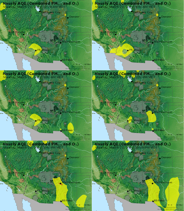
An animated EPA AQI map shows the extent of the dust event based on their interpolation scheme.

Sunday, March 20, 2011

March 20 - Wind and blowing dust event notification for Monday.

I am still in San Diego today and it felt good to be in some rain.  It is totally clouded over in San Diego so I'm not able to see any sky. I would have hoped for less wind and a little warmer. Here are some summaries of today's conditions and a look at the next blowing dust forecast for the NM DOH study.

The EPA AQI forecast for today was green for the whole region.Nothing unexpected here.

Regarding the transport of Asian dust I have been discussing over the past couple of days, I am looking at this morning's NAAPS and seeing a part of that airmass remaining over the southwest but surface concentrations are predicted to be very low to zero. The optical depth product is showing mainly a smoke signature and less dust while the surface concentrations are picked up in the model over southern Calif. and Nevada.
Today winds were gusty in places but PM10 did not reach high levels. For example at the NMED Chaparral station hourly averaged winds were not high reaching only up to 5 m/s in the afternoon with peak gusts up to 13 m/s. PM10 at that time were in the range of 10 to 50 ug/m3. Only after the winds died down did the PM10 climb up to over a 100 ug/m3.

High winds are still on for Monday afternoon and into the evening. Looking at the RUC 00Z run the winds are picking up at 18 UTC (noon MDT) on Monday in the Bootheel region first.
By 21 UTC (3 pm MDT) on Monday the 03Z RUC run is showing more winds mixing down over Dona Ana and Luna counties.

The National Weather Service is forecasting winds to be in the range of 27 to 30 mph in the afternoon with gusts up to 41 mph in Las Cruces.  This is in the range for some of the more erodible areas to emit dust but not a major event. For the area around Antelope Wells the winds are predicted to be in the range of 33 to 36 mph with gusts to 50 mph on Monday afternoon.  Their forecasts mention "areas of blowing dust" so I will keep the alert on for a moderate dust event on Monday afternoon from around 3 to 6 pm.

Saturday, March 19, 2011

March 18 and 19 summary

March 18 - I was on the road today driving to San Diego on interstates 10 and then on 8. No internet access at hotel on the 18th so I'm posting events on the 19th.

Very hazy past Tucson and visibility lowest around Yuma. Some of it was due to local source blowing dust but I didn't see a lot along the freeway. Still very hazy past El Centro looking west. Haze looked high and not from sources in California. My guess it's the Asian dust plume based on these observations, experiences from past Asian dust episodes, and the NAAPS model predictions. Below is the NAAPS model output at midnight on the 18th. The upper left panel shows dust optical depth as the green blob over much of the US and eastern Pacific.
Looking at MODIS AOD off the coast of southern California and Baja you can see a verification of the NAAPS model from the higher than average AOD. Below is a map of AOD from the afternoon Aqua pass. Map courtesy of the IDEA project. The higher AOD stands out as the lighter blue whisps over the ocean.


March 19 - I'm in San Diego today and finally have internet access. Spent the afternoon at the UCSD campus so a little behind in posting today.

Today's winds started out from the west and eventually from the southwest. Below is the prediction at 18Z (noon) for winds based on the 20-km RUC. Areas in the Paso del Norte saw a little more winds than the rest of the region as seen below.
Observations backed this up with winds causing some windblown dust at the Sunland Park City Yard. Peak hourly PM10 reached 316 ug/m3 at 3 pm.

I am still expecting a windy Monday based so far on both NAM and GFS guidance. Below is the output from the 80-km NAM run at 00Z. It shows widespread high winds across our study region at 00Z (6 pm).

Below is the same time on Monday but from today's 00Z GFS run. It looks like the NAM model brings the highest winds further north while the GFS shows maximum wind impacts in the Bootheel region.