

The afternoon upper level map is showing us moving out of a trof and into a ridge. This is going to bring us back into a warming trend and much lower winds. We should be reaching high temperatures in the upper 70s in this pattern. This calm period will give us time to examine at the data from yesterday and prepare for the next wind event.

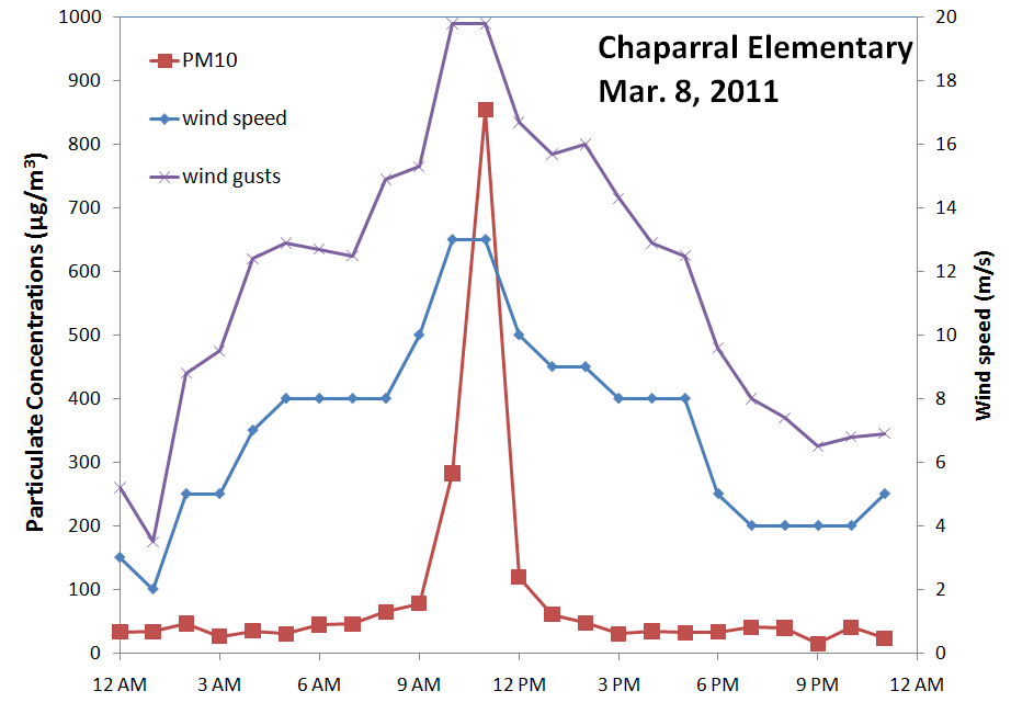
This morning brought peak winds between 10 and 11 and some dust. Here at the NMED Chaparral station PM10 reached 855 µg/m3 at 11 am.
The Sunland Park City Yard station started to see high PM10 at 10 am with it peaking at a concentration of 643 µg/m3 at 11 am.

Ozone at the Hurley station ranged from 50 to 70 ppb range today. Peak hourly ozone was 74 ppb at 5 pm. Peak 8-hr ozone a little later in the day is around 68 ppb. Looking at other ozone stations in the region, we see that Chiricahua ozone ranged from 40 to 60 ppb, Deming 20 to 40 ppb, Las Cruces 40 to 60 ppb.

One thing to consider is that there is a wildfire burning almost west of Hurley. The Quail Ridge fire burned 12 houses and 1,776 acres by Tuesday. With winds from the west, it is very likely that the fire emissions had some impact on the ozone. Below is a MODIS-Aqua image from yesterday with the fire outlined in red and the Hurley ozone monitoring site shown as a green push-pin.

Ozone forecasts from the NOAA/EPA system show hourly ozone in the 60 ppb range on Wednesday afternoon. Below is the ozone forecast map for 5 pm MST on Wednesday.


No comments:
Post a Comment