I am still in San Diego today and it felt good to be in some rain. It is totally clouded over in San Diego so I'm not able to see any sky. I would have hoped for less wind and a little warmer. Here are some summaries of today's conditions and a look at the next blowing dust forecast for the NM DOH study.
The EPA AQI forecast for today was green for the whole region.Nothing unexpected here.
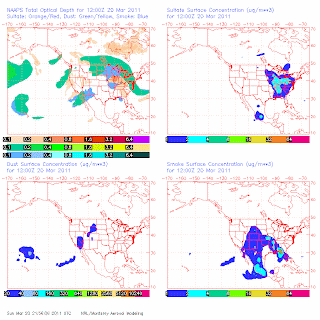
Regarding the transport of Asian dust I have been discussing over the past couple of days, I am looking at this morning's NAAPS and seeing a part of that airmass remaining over the southwest but surface concentrations are predicted to be very low to zero. The optical depth product is showing mainly a smoke signature and less dust while the surface concentrations are picked up in the model over southern Calif. and Nevada.
Today winds were gusty in places but PM10 did not reach high levels. For example at the NMED Chaparral station hourly averaged winds were not high reaching only up to 5 m/s in the afternoon with peak gusts up to 13 m/s. PM10 at that time were in the range of 10 to 50 ug/m3. Only after the winds died down did the PM10 climb up to over a 100 ug/m3.
By 21 UTC (3 pm MDT) on Monday the 03Z RUC run is showing more winds mixing down over Dona Ana and Luna counties.
The National Weather Service is forecasting winds to be in the range of 27 to 30 mph in the afternoon with gusts up to 41 mph in Las Cruces. This is in the range for some of the more erodible areas to emit dust but not a major event. For the area around Antelope Wells the winds are predicted to be in the range of 33 to 36 mph with gusts to 50 mph on Monday afternoon. Their forecasts mention "areas of blowing dust" so I will keep the alert on for a moderate dust event on Monday afternoon from around 3 to 6 pm.


No comments:
Post a Comment