Battling my comcast internet connection and finally back on line. Amazingly dry airmass today. I've noticed some dewpoint depressions more than 100 degrees F in southern NM. At 5:51 the dew point depression at KELP was 112 F (T=91/Td=-21). The Davis VantagePro I'm looking at here in Las Cruces is at its limits with low RH. It's showing 0% RH and -120F dewpoint, obviously out of its range. The HOBO sensor located next to it is showing an RH of 5% and a corresponding -12F dewpoint temperature at 8 pm.
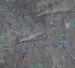
Several wildfires were active today with multiple smoke plumes visible in our region. The NOAA HMS smoke product shows three wildfires to our west with plumes extending toward the northeast. Two of these fires are located at the border or in Mexico.
At 6:45 pm the smoke plumes are clearly visible on the GOES satellite. You can even pick out the shadows the smoke plumes are making on the ground. If I had time I could estimate the height of the smoke using this image.
The outlook for dust looks positive for tomorrow. That is, positive for the right ingredients of high winds and very, very dry soils. Below are the forecasted RUC winds at 3 pm tomorrow. They look to be more from the southwest.
Still no signs of precipitation over the next 5 days. The QPF map below shows the precipitation north of us again and over east Texas.


No comments:
Post a Comment