Our observer for the NMSU Coop saw snow flurries around 5:30 am but no accumulation and no recording in the rain gauge. I saw a line of Kelvin-Helmholtz instability clouds around 11:30 am today looking south of Las Cruces. It wasn't a good example but you could see the breaking waves. The Deming profiler showed a nice example of easterly winds at the surface and westerlies aloft, a 180 degree difference in wind direction between 3 and 4 km MSL.
Here is the view looking west from campus.
Short-term particulate exposure from the morning high winds was highest in Deming. The peak PM10 was 244 µg/m3 with hourly averaged northeast winds of 11 m/s (25 mph) and 16.4 m/s (37 mph) gusts.
Peak east winds (blowing from the east) at the Sunland Park City Yard station were 9 m/s (20 mph) with gusts of 13.2 m/s (30 mph) at 10 am. Particulate concentrations were low in the morning considering the wind speeds. PM10 peaked at 73 µg/m3 and PM2.5 at 6 µg/m3. The evening peak in PM10 reached 198 µg/m3 and there is a possibility that it was not caused by wind erosion from local sources due to the wind speed.
The east winds at the Anthony site were lower but peak particulates were higher during the windiest part of the morning. Peak PM10 was 162 µg/m3 and PM2.5 was 10 µg/m3. The anemometer heights are lower at the Anthony site that might make up for some of the difference in wind speed.
The winds and particulate concentrations at Chaparral look similar to the Sunland Park City Yard site. Winds were from the east-northeast during the morning.
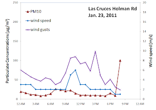
Looking north at the NMED Las Cruces Holman Road station we saw lighter winds and less particulates.


No comments:
Post a Comment