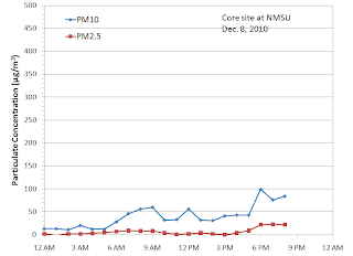
The highest exposure to PM today is in the afternoon and evening. The Las Cruces core site showed an increase over the course of the day and was 84 µg/m3 by 8 pm.
PM10 in Deming showed a peak of 122 µg/m3 at 5 pm today.
Looking at the radar wind profiler south of Deming we see a change in transport direction right about time, moving from a southeasterly direction to a southwesterly wind.
In Anthony we see an evening event starting at 5 pm and continuing at least until 9 pm. Concentrations were higher here than the northern sites. PM10 was over 200 µg/m3 and PM2.5 peaked at 29 µg/m3.
At the Sunland Park City Yard we see a strong 500 µg/m3 low wind peak at 6 pm. PM2.5 peaked at 98 µg/m3 at the same time. PM2.5 to PM10 ratio was 0.2 at 6 pm which is about what we expect for this type of event.
It's possible that smoke smoke from a fire in Mexico was transported north and visible as the afternoon peak in PM. The NOAA HMS smoke fire location map is shown below. The analyst noted the smoke plume being transported toward the northwest but winds could have shifted but it's hard to say for sure.
Looking at the forecasts it is supposed to warm up to 69F on Friday and 68F on Saturday. A shortwave trough and backdoor cold front is forecasted to drop in for a visit on Saturday night bringing in some wind and cooler temperatures for Sunday and early in the week. As of 11 pm most of the study area is under a moderate air quality (AQI) rating.


No comments:
Post a Comment