
High winds are expected this afternoon across the region. Below is our RUC forecast for 6 pm.

In terms of timing the winds look to be the strongest later in the afternoon. Below are the forecasted winds from the RUC model in Cd. Juarez with the peak at 00 UTC.


The NAAPS model is also predicting this as well.

There is supposed to be a mountain in the background (2:35pm)

Looking out the window at NMSU toward the west the visibility started to decrease significantly around noon. Notice a strong gust at 1:29 pm.
Below is a preliminary summary of maximum winds gusts today from airport weather stations.
time gust
Location MDT mph
Las Cruces airport 17:30 53
Deming airport 11:05 58
El Paso airport 14:29 47
Alamogordo airport 13:51 51
I was out at the Diamond Springs development around 4:45 to 5:00 pm and I recorded a 19.1 m/s (43 mph) gust during the 15 minutes I was there. It almost blew me over.
PM2.5 concentrations across the region were very high all afternoon. Peak hourly PM2.5 concentrations ranged from a 211 µg/m3 at Sunland Park City Yard, a 195 µg/m3 at Anthony, a 101 µg/m3 at Sunland Park Desert View, and a 99 µg/m3 at the Santa Teresa Border Crossing.

Samples of PM2.5 were collected at my house in the Highrange Neighborhood today with a DustTrakII. Peak PM2.5 occurred about 5:45 pm MDT at this location. The instrument was located 2-meters above the ground. The short, high intensity peaks were due to wind gusts.

The NMED Deming station recorded very high hourly PM10 concentrations. At 10 am the hourly PM10 concentration was 8708 µg/m3 with a wind gust of 26 m/s (58 mph). That might be the highest I've seen all year. I made a separate plot for this site since the concentrations were so high.

The remaining PM10 sites in southwestern New Mexico show a consistent dust storm start time at noon and end time of 8 pm.
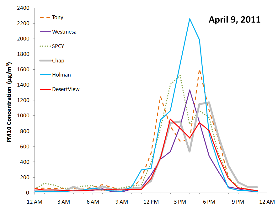
In summary, every station except the Santa Teresa Border Crossing exceeded the PM10 and PM2.5 NAAQS today.
Below are ceilometer backscatter plots during this dust event. The plot below shows backscatter from 8am to 11 am. The dust event starts at 10:45 am with the bright red backscatter appearing. Prior to that we had a thin cloud at around 2.5 km above the ground.


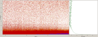


Below are ceilometer backscatter plots during this dust event. The plot below shows backscatter from 8am to 11 am. The dust event starts at 10:45 am with the bright red backscatter appearing. Prior to that we had a thin cloud at around 2.5 km above the ground.

and from noon to 3 pm

and from 3 to 6pm

and from 6 to 9 pm

and from 9 to midnight. The dust storm subsides just before 10 pm.

At 6:30 pm the GOES west GASP aerosol optical depth product showed a glimpse of the dust optical thickness. Over our region AOD varied from 0.4 to 1.0 with AOD at 1.0 over the ceilometer.

No comments:
Post a Comment