Radar picked up rainfall on June 17 along the border area in addition to some thunderstorm outflow. I flew in last night at around 10:30 pm and the area around El Paso was hazy from outflow windblown dust. Below is an animation of the accumulated rainfall from the Santa Teresa weather radar from 16 to 03 UTC (10 am to 9am). Based on CoCoRaHS observers, a few locations in Las Cruces measured rain. However no measurable rainfall fell on the NMSU campus at our NWS Coop station.
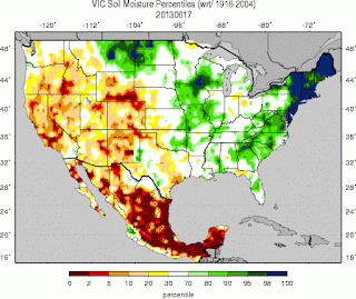
Very dry soils remain a problem for agriculture, air quality and wildlife (just to name a few) in the border region as shown in the soil moisture map below. The darkest red shades highlight soil percentiles below the 2nd percentile.
Wildfires continue to impact the border area with smoke from the Silver Fire travelling eastward across Sierra and northern Otero counties. Some smoke has impacted other areas to the south during the night hours when winds are light and channeled mainly by topography. Below is a NOAA GOES visible satellite image at 5:32 pm. There are also smoke plumes traveling northeastward from the mountains in NE Sonora Mexico.
By 6:30pm smoke plumes can be seen below spreading over most of northern Dona Ana, Sierra, and into Otero counties. Based on the brightness from this visible image, there might have been some pyrocumulus generated from the Silver Fire in the Black Range. Smoke from fires in Mexico look to impact central Hidalgo over the bootheel and potentially Deming and Lordsburg overnight.


No comments:
Post a Comment