The NWS forecast for Las Cruces is "Areas of blowing dust after 11am. Mostly sunny, with a high near 68. Windy, with a southwest wind 11 to 14 mph increasing to between 30 and 33 mph. Winds could gust as high as 45 mph." I'm already seeing the short wave energy in the high upper level winds at the Deming profiler. We have 50 knot (58 mph) winds at 2.5 km.
The EPA AQI forecast shows for good (green) air quality today but I believe it doesn't take into account our high winds. To augment the particulate monitoring network we have the DustTrack, ceilometer, and a MetOne profiler running at the NMSU weather station today. These instruments are providing particulate information at 1-minute intervals.
Here is a plot of the DustTrak at the campus weather station during this event.
The other noteworthy story is a low wind high PM event in the Paso del Norte last night and this morning. However the PM concentrations during the low wind event pale in contrast to the high wind event in the afternoon.
Here in NMSU at 1 pm I can see the sky turning whitish compared to the nice blue from this morning. At 2 pm the haze is starting to increase and winds are more steady.
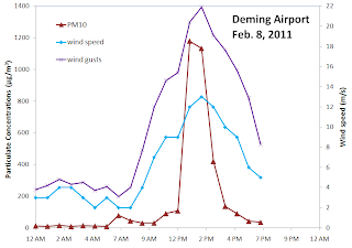
At Deming we saw high PM10 concentrations over1100 µg/m3 for two hours this afternoon.
A similar story in Anthony
At the West Mesa site
The dust blocks the setting sun at 5:35 pm. There were enough dust so that you could look at the sun. All of that is dust and is not clouds.
and a view of the whole day


Dave,
ReplyDeleteI plan to check your blog before I leave for work tomorrow. It's getting hard to know how to dress for the day.
Thanks for the blog site.
Erin