Saturday, December 31, 2011

Dec 31 -

Another low wind, high PM evening at SPCY. It warmed up to a very nice day today with some highs more than 10 degrees above average. Looking at the highs around the region, the Las Cruces airport reached 68, El Paso airport 70, and Deming 71.  Below are this morning's observations at a few NWS Cooperative weather stations.

                 Yesterday           Today
Station       High(F)  Normal     Low(F)  Normal  Record Low
NMSU            66        55        29      28      6 (1895)
Antelope Wells  71        61        29      28     17 (2010)
Hachita         64        56        23      26      6 (1958)

The Airnow AQI forecast for our region is green or good air quality. However, with the low winds today we're seeing a build up in pollutants.
I was at the SPCY station today swapping filters and I could smell a whiff of wood burning now and then the whole time I was there from 3:30 to 4:30pm.  I'm not totally sure it was wood but it had that kind of semi-sweet smell similar to when I visited an old time blacksmith's shop. There were some smoke plumes in Mexico while I was there. I took some photos but my camera corrupted the memory card.  

Here I describe the particle counter that I installed at the SPCY station.
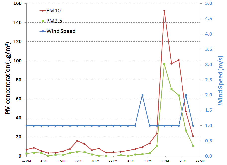
There was a 6-hour long low wind, high PM event at the SPCY station tonight. Peak hourly PM2.5 was 138 µg/m3 at 7 pm. The chart below shows the hourly PM10, PM2.5, and 10 meter wind speed from the NMED station.
The particle sizer clearly shows the low wind event with the 0.3 micron size bin increasing by a factor of 20 to 30 during the event compared to mid-day values. The chart below shows the particle count data for the 0.3 and 10 micron bins over the past two days. Up to this point we have collected enhanced data on the nature of the low wind PM spike for two episodes (highlighted in yellow).


Friday, December 30, 2011

Dec. 30 -

Forecasting another low wind event tonight. Below are this morning's observations at a couple Cooperative weather stations.
                 Yesterday           Today
Station       High(F)  Normal     Low(F)  Normal  Record Low
NMSU            59        56        29      28      4 (1895)
Hachita         64        56        23      26      6 (1969)

Temperatures have finally climbed above average in Las Cruces. The NWS forecast is calling for low winds tonight but from the north. Below is a wind forecast from the 15Z RUC model at 8 pm tonight.
 The AQI forecast for today again shows our patch of moderate air quality over the Paso del Norte and El Paso county.
Looking past the weekend and into next week the 12Z GFS forecast conditions look good for low wind events from the 3rd to 5th but after that I'm not that confident since the winds start to increase due to an upper level trough moving in to the area.
6 pm Minivols are set to run from 6pm to midnight tonight to capture a low wind high PM event. Filters used today include DUPT001 (Teflon) on sampler SN5360 and DUPQ001 (quartz) on sampler with SN5361.  I also downloaded the data from the profiler and a time series plot of particle counts for small (0.3 micron) and coarse (10 micro) is shown below. During the low wind spike yesterday, highlighted in yellow, the small particle counts increased greatly compared to the mid-day values. Coarse particle counts also spiked as well showing the plume is also mixed with larger particles. Particles with diameters of 0.3 micron are likely combustion related as opposed to coarse particles that are probably derived from soil dust.
10 pm Forecast was on the mark. A moderate to strong, low wind, high PM event was recorded at the SPCY station tonight. Peak hourly PM2.5 was 85 µg/m3 at 10 pm. 

The NMED AQB website showed orange stage AQI late tonight for PM2.5. Orange AQI is "unhealthy for sensitive groups."
From satellite the OMI NO2 product shows a pattern of a stagnating air mass with accumulating NO2 over urban and polluted industrial areas. Below shows the El Paso area shaded in yellow. While not as intense as the NO2 in the Four Corners and Albuquerque it still indicates a build-up of pollutants in this air basin.


Thursday, December 29, 2011

Dec. 29 -

We are installing SPCY samplers today. Below are this morning's observations at a few Cooperative weather stations.

                 Yesterday           Today
Station       High(F)  Normal     Low(F)  Normal  Record Low
NMSU            55        56        27      28      13 (1983)
Antelope Wells  62        57        26      25      12 (1997)

Temperatures are finally climbing up to near normal around the region. The AQI forecast for today again is showing an area of yellow or moderate air quality over the Paso del Norte and El Paso county due to PM2.5.
Looking at the GFS model output for guidance on sampling days at the SPCY station I see a possibility today, tomorrow, and possibly Saturday. On Sunday a cold front is expected to crank up winds a little and disperse pollutants. By Tuesday we could see the low wind events reappear.
We have installed most of the instrumentation at the SPCY station including the two minivols and the MetOne particle profiler. While at the station this afternoon there were a few times I could smell wood burning even over the waste water treatment plant sulfur smell. The profiler is located midway between the PM2.5 Partisol and the PM10 Wedding as shown below. The profiler is running and set to accumulate particle counts every 60 seconds and the CR1000 saves the data at 2 minute intervals summing particle counts over that time. All instruments deployed today are running off batteries. The profiler batteries are charged with a 10W solar panel and the minivol batteries are charged up in the lab before each sample day.
and the minivols are attached to the power pole at the northwest corner of the station. We will collect simultaneous filter samples on a Teflon and quartz filter with these.
All of the inlets are of the same height as the SPCY station instruments at approximately 10 feet above the ground.There was a 2-hour low wind, elevated PM event right after we left the station this evening.
On the national scale, ag burning looks to be active today from the NOAA HMS fire detection product. Note the high density of red dots (fires) in Texas. I see just three fire detects in NM.

Wednesday, December 28, 2011

Dec. 28 -

Below are this morning's observations at a few Cooperative weather stations.
                 Yesterday           Today
Station       High(F)  Normal     Low(F)  Normal  Record Low
NMSU            53        55        24      27      5 (1987)
Antelope Wells  60        57        25      25      7 (1997)
Glenwood        58        55        24      25      8 (1987)

Forecasted high temperatures in the region range in the upper 50s in the lower elevations to the lower 50s in the foothills. The AQI forecast shows an area of moderate air quality in the Paso del Norte today due to PM2.5.
I'm still looking at more favorable conditions for the the low wind high PM events in Sunland Park. Looking at the GFS model this morning and pulling out temperatures, surface winds, and 500mb heights, I see a couple of periods that could be good sampling days. Although these variables are not perfect predictors of the low wind events, they are useful. I am omitting the evenings of January 1-2 to possibilities of too much wind for this type of event.
The OMI NO2 product shows localized patches of tropospheric NO2 indicating little wind movement and pollutant build-up around the urban areas.
The NMED SPCY station data wasn't updating tonight so I'm not sure if there was a low wind event but the Anthony station indicating an evening peak.


Tuesday, December 27, 2011

Dec. 27 -

Below are this morning's observation at the NMSU weather station.
   Yesterday           Today
High(F)  Normal     Low(F)  Normal  Record Low
  49        55        21      27      5 (1987)

We have another day of clear skies over the border region while we sit under an upper level high. This system should bring up the daily high temperatures to above normal. Below is a time series graph of surface temperature (red line), wind speed (blue line), and 500 mb geopotential heights (green) at the grid cell over Sunland Park from the 80km GFS model (12Z run). The green trace are the heights and show the ridge building and peaking on New Years Day. This tells me we should have a good window for sampling the low wind, high PM events in that area at least over the forecast time span. A little short wave my enter the area on the first of the year but the NWS is indicating only high clouds and a slight cooling through the January 2. After that the model is indicating a continual warming trend.
Today's air quality forecast shows it in the good range today.
Areas in central California have it the worst in the country with much of it in the orange and red AQI. The Smog Blog has more discussion on this.

We saw another low wind high PM event at the Sunland Park City Yard station tonight. This one is stronger than last night's event. We were preparing the particle size instrument to be deployed at this location today. I had a little problem programming the CR1000 logger but I think the problem is solved. This instrument will log particle counts from 0.5 to 10 microns in 8 size bins. I will also be deploying the minivol samplers as soon as I get access to the filters in the lab.
The AQI forecast for Wednesday is showing an area of moderate air quality over the El Paso area due to PM2.5.

Monday, December 26, 2011

Dec. 26 -

Below are this morning's observation at the NMSU weather station.

   Yesterday           Today
High(F)  Normal     Low(F)  Normal  Record Low
  42        56        21      27      18 (2004)

Skies over the region were clear today giving us a view of the snow cover that remains from the storm this weekend. Below is an MODIS Aqua image at 20:20 UTC from the LANCE website.
Since I see an upper level ridge building, I don't seen any more precipitation this year. The QPF doesn't show any precipitation as least for the next 5-days either.
Based on the GAPS aerosol product from the IDEA website, column aerosol was low today.
Another low wind, high PM event occurred tonight at the Sunland Park City Yard station although very weak compared to last night.

Sunday, December 25, 2011

Dec. 25 -

Merry Christmas everyone!

 We had a low wind, high PM episode at the Sunland Park City Yard station tonight. This one was unique because of the high PM2.5 to PM10 ratio probably due to high soil moisture and very little fugitive dust from roads.

Saturday, December 24, 2011

Dec. 24 -

Below are this morning's observation at the NMSU weather station.

   Yesterday           Today
High(F)  Normal     Low(F)  Normal  Record Low
  32        56        27      28      16 (1990)

We picked up 0.15 inches of liquid water precipitation over the last 24-hours out of 1 inch of snowfall. On the ground at NMSU we had 2 inches of snow this morning.  As of this morning we have 1.52 inches of precipitation this month.  Most of the region accumulated nearly an inch more of snow on top of the snow from Friday. Hachita measured a trace, east Deming 1.5", about an inch in Silver City, up to 3" in Las Cruces, and 3.4" in parts of El Paso. The NWS Ridge2 precipitation product shows most of the rain for this storm (past 3 days) and snow fell on NW Dona Ana, NE Luna and southern Sierra counties.
Today's MODIS Aqua image shows the extent of the snow cover using bands 7-2-1 mapped to Red-Green-Blue from the LANCE website. The turquoise areas in the middle of the image show snow cover. Based on this much of the Bootheel didn't receive as much snow as the rest of the region.
A low intensity, low wind, high PM event started out this evening at the Sunland Park City Yard (SPCY) station today. Peak PM2.5/PM10 ratio was 0.85 at 10 pm tonight. Because of the recent precipitation I would expect that the coarse fraction fugitive dust component to the low and most of the particle mass from the fine fraction. That is basically what the plot shows except that it doesn't show what the aerosol is made of. From past studies that fine fraction is organics and probably from burning.
If all goes well, we will be sampling next weekend and potentially by the end of the week for fine fraction organics. We'll be deploying filter samplers and a particle sizer to investigate organic aerosols at this site. I'll be talking more about this in upcoming blog entries.

Wednesday, December 21, 2011

Dec. 21 -

We'll be seeing a little warm-up today before the next storm system moves over us tomorrow. Below are this morning's observation at the NMSU weather station.
   Yesterday           Today
High(F)  Normal     Low(F)  Normal  Record Low
  46        58        27      29      11 (1977)

With the next storm system we may pick up some more moisture in across the study region. Below is the day 1 to 3 Quantitive Precipitation Forecast (QPF) for Wednesday to Saturday.
The CPC 6-10 day forecast for temperature looks odd. Look below and see what I mean with the blue "B" or below normal probabilities of temperature. It doesn't fit my pattern for a La Nina. But then I'm not surprised. I'm not questioning the fact that we have a La Nina but the impacts to our area are not like last year.  However the CPC map does reflect the pattern of these closed upper level lows from this month.
The Air Quality Index (AQI) forecast for today is calling for good air quality.
There was an announcement today of the new Mercury and Air Toxics Standards (MATS) from the US EPA.  I listened in the live announcement by Administrator Jackson on UStream. The new standards control emissions of mercury, arsenic, chromium, nickel, and acid gases (HCl and HF). This is targeted to coal fired power plants and based out of the Clean Air Act. In the rule emitters have 3 years to comply with rule. Those who are in the process of complying may get another year to comply. According to the EPA MATS website for NM, the rule will "prevent up to 24 premature deaths in New Mexico while creating up to $200 million in health benefits in 2016."


Tuesday, December 20, 2011

Dec. 20 -

Below I highlight the total precipitation amounts from the last storm based on the NWS Ridge2 precipitation analysis product. Radar did not pick up precipitation in southwestern Luna and southeastern Hidalgo counties. It was dry again at the Antelope Wells Coop station.
Below are this morning's observation at the NMSU weather station.
   Yesterday           Today
High(F)  Normal     Low(F)  Normal  Record Low
  45        58        35      28      15 (1973)

In addition to the 0.38" yesterday we observed another 0.05 inches of precipitation over the last 24-hours. With the close of the year approaching, our total precipitation at NMSU so far is 6.65 inches, 68 percent of the long term average.

Below is this morning's MODIS satellite image from LANCE showing the extent of snow cover along the border. The pins are NWS Cooperative stations. The image enhances the snow cover as the turquoise color. The very light turquoise are clouds like those over much of the area between Silver City and Las Cruces. You can see the snow over the San Andres Mountains.

The air quality forecast is showing good in our area today as the map below shows.

Monday, December 19, 2011

Dec. 19 -

Most of the southwest border received precipitation overnight except for areas around the Bootheel region. The Antelope Wells station did not observe any precipitation yet.
Wind gusts have been in the 40+ mph range this morning with the highest at the Las Cruces airport as of 9 am. We had a brief change from rain to snow for a short time this morning around 7:30am to 7:45 in Las Cruces but no accumulation.  Below are this morning's observation at the NMSU weather station.

   Yesterday           Today
High(F)  Normal     Low(F)  Normal  Record Low
 54        57        39      28      13 (1996)

We had 0.38 inches of precipitation over the last 24-hours. So far at NMSU we had 1.23 inches of precipitation this month. Recall that our 30-year average (1980-2010) for this month is 0.72 inches.

With the precipitation, I expect no large scale issues in air quality today. Soil moisture is running in many locations so wind blown dust is not expected. As expected the AQI forecast shows all good air quality.

Northern NM looked to be hardest hit from this storm. Snow and blizzard conditions closed down I25 north of Santa Fe and I40 between Moriarty and the Texas state line. In southern NM, a weather spotter in Cloudcroft observed 6.5 inches of snow this afternoon.

A brief gap in the clouds this afternoon let in some sunlight from NMSU campus.

Sunday, December 18, 2011

Dec. 18 - More rain and snow to come

We're in for some significant precipitation for much of the border region on Monday. So far by late Sunday night we've seen some isolated spots of rain but not widespread. Radar estimates show most of the highest rates in Dona Ana count. A few reports of hail west of La Mesa through twitter this afternoon. At my CoCoRaHS in Las Cruces there is at least 0.2" by 10 pm Sunday. There's enough dynamics in this storm to produce thunderstorms and I've seen lightning strikes this evening. The NWS QPF maps are showing 0.2 to 0.5 inches in central Dona Ana county by the end of this storm. Significant accumulations of snow in the Gila and Sacramento Mountains as well. Both El Paso and Albuquerque NWS forecast offices are providing a weather briefing for this storm on their websites.
Most of the state is running above average for the month of December even before this storm hits. Below is the percent of average for the month from the WRCC. Note that all colors green, blue and purple are more than 100 percent of average. Only area in western McKinley and in southern Lea county haven't seen much precipitation this month.
With this storm system we could see some improvements in the drought lines in the drought monitor. We'll make an assessment after the precipitation totals come in on Monday. Based on a quick look at the Midland radar this evening there looked to be some precipitation that fell in southeastern NM. This would be particularly good news for folks in southern Lea county although they would have liked to see it earlier in the year.
With these wet storm systems the air quality will remain in the good range. Winds are forecasted to be gusty during the storm system but I'm not expecting much or any dust.  I haven't heard of much in the way of harvesting pecans in the Mesilla Valley due to the moisture on the ground. We have been in the waiting stages for a particulate emissions study but it may have to wait for another week.

Friday, December 16, 2011

Dec. 16 -

We're looking forward to another rain event in the southwest border region this weekend. An upper level low is spinning off the coast of northern Baja California and will migrate slowly and bring in moisture from the Pacific Ocean. By Monday morning the low will sit over us and give us some precip. The 5-day QPF product is showing more precipitation for north-central and northeast NM than down south.
The AQI forecast for today is good air quality with green over all the state.
I read today that the last GOES-11 satellite was taken off line December 5, 2011 at 21 UTC. GOES-11 became operational in 2000 and has provided us in the western US with our satellite imagery at an altitude of 22,300 miles from the surface of the earth. This satellite was retired and replaced with GOES-15 on December 6th at 15:46 UTC. GOES-15 has been improved over the old one but still serves the same purpose in providing near real time imagery for earth and atmospheric observations.

Wednesday, December 14, 2011

Dec. 14 -

The big story is the precipitation across the region. Below shows the estimated rainfall total for the last 24-hours from the NWS Ridge2 product.

Below are this morning's observation at the NMSU weather station.
   Yesterday           Today
High(F)  Normal     Low(F)  Normal  Record Low
 54        58        40      28      12 (1985)

We had 0.22 inches of precip over the last 24-hours. So far at NMSU we had 0.85 inches of precip this month. Our 30-year average (1980-2010) is 0.72 inches.

Another storm system is on the way to bring in more precipitation to the border area. The 4 and 5 day NOAA QPF is showing precipitation across most of New Mexico.
Not surprising, the EPA AQI forecast is showing good air quality over the border region for today.

Tuesday, December 13, 2011

Dec. 13 - Rain falling along the border today.

So far we are seeing rain falling across the region and in some cases a lot of rain. The report from the Antelope Wells Coop station says they had 1.60 inches over the past 24-hours.Based on the Santa Teresa radar this morning the highest precipitation fell across northern Luna and southwestern Sierra counties.
At NMSU rain started after the 7 am observation so our rain amounts will be shown in tomorrow's report. I had a trace of precipitation at 8 am at my CoCoRaHS site NM-DA-201. NOAA CPC just posted their 8-14 day forecast for precipitation and I am encouraged to see the ABOVE normal precipitation for eastern NM.