Friday, December 31, 2010

Dec. 31 - A cold start to the day with a low of 27F at NMSU Coop site, 25F at the Las Cruces Airport, 33F at the EL Paso Airport, and 16F at the Deming Airport.  Snow can be seen at the higher elevations. Here is a photo of Organ Mountains at Dripping Springs this morning.
We could get a little more precipitation out of this storm based on the forecasts. The QPF map shows some precip could fall in southern Hidalgo and in Grant County.
Air quality is in the good range this morning. The core site in Las Cruces was showing hourly PM10 concentrations in the 10 µg/m3 range.
At the end of the day air quality remained good even with fireworks. Here is the NMED Sunland Park City Yard station PM10 and PM2.5.

Thursday, December 30, 2010

Dec. 30 - Major high wind, dust event - 10:05 am dust hit campus having seeing it coming from the west. Here is the 20km RUC2 10-m wind speed at 11 am. Colors show winds in meters per second.
The Deming airport station was hammered hard with blowing dust starting at 8 am this morning. Peak PM10 was 4875 µg/m3 at 11 am. This site will have an EPA PM10 exceedance regardless of the rest of the day. I make note that the wind gusts peaked at 25.5 m/s or 57 mph during the 11 am sample hour.

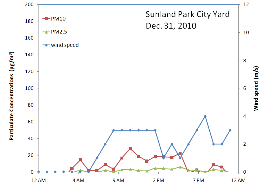
Here is the Sunland Park City Yard station particulates today with peak PM10 of 2697 µg/m3 and PM2.5 of 173 µg/m3.

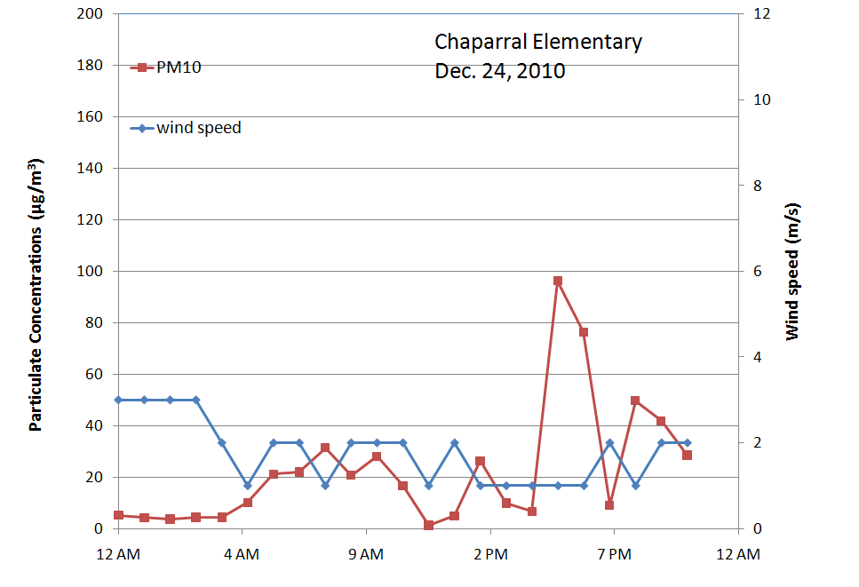
A similar pattern at the NMED Chaparral station.
At the core site in Las Cruces we see the dust cloud starting at the 10 am sample and lasting 4 hours. The beta gauge sample was set for a maximum 1000 µg/m3 so the actual maximum concentration was not measured.
Here is the view from NMSU looking west today.

The Las Cruces west mesa station recorded a peak hourly PM10 at 2335 µg/m3 at noon. Maximum wind gusts of the day were 26.1 m/s or 58.4 mph during the noon sample hour.

Below is a view of the dust looking south on I-25 near the University exit at 1:17 pm.
After the wind, dust, and rain, it snows! Pic below was taken at 3:08 pm looking west.
I read tonight that highway 11 from Deming to Columbus was closed for a while and highway 180 from Deming to Hurley was closed from milemarker 125 to 160. By the evening only the roads with ice and snow are still closed. See the map below from nmroads.com.
Some pretty tight pressure gradients at 21 UTC (2 pm) today following that cold front. I can see why we had some of those high winds. At 12:14 pm the Las Cruces airport ASOS was measuring southwest winds of 46 mph with 61 mph gusts with 1.75 mile visual range. I read on the El Paso Times website that there was a report of pea-sized hail in downtown El Paso a little before 3 pm.
Here's the regional AQI map animation from today.
So where did all this dust go? Carlsbad saw the dust too. Maybe some local and some transported, but they had quite a bit of PM2.5 about a couple hours after our show.

Wednesday, December 29, 2010

Dec. 29 - High winds are forecasted for today and again on Thursday. Today's 20-km RUC2 wind speed at 21 UTC (2 pm) shows a widespread area of high winds in southwest NM.

A portion of the National Weather Service statement this morning on the storm is as follows
* WINDS...SOUTHWEST WINDS 25 TO 35 MPH WITH GUST TO 45 MPH THIS
  AFTERNOON...AND SOUTHWEST 35 TO 45 MPH WITH GUSTS TO 60 MPH
  THURSDAY AFTERNOON.

* TIMING...WINDS INCREASING TO 25 TO 35 MPH LATE THIS MORNING INTO
  THE AFTERNOON. WINDS WILL DECREASE TO 20 TO 30 MPH BY EARLY THIS
  EVENING. ON THURSDAY WINDS WILL INCREASE OUT OF THE SOUTHWEST TO
  35 TO 45 MPH WITH GUSTS TO 60 MPH. AGAIN THE WINDS WILL DECREASE
  BY EARLY EVENING TO 20 TO 30 MPH.

* VISIBILITY...BLOWING DUST IS LIKELY BOTH DAYS WITH FREQUENT
  VISIBILITIES OF AROUND 5 MILES...WITH LOCAL VISIBILITIES OF ONE
  MILE OR LESS IN DENSE BLOWING DUST. POOR VISIBILITIES ARE LIKELY
  TO HAVE THE BIGGEST EFFECT SOUTH OF HATCH ALONG THE INTERSTATE
  10/INTERSTATE 25 CORRIDORS AND VARIOUS OTHER ROADWAYS.
At 9 am winds were light in the range of 5 mph on campus.
 
At 3 pm PM is starting to increase at the core site in Las Cruces.

Not much visible dust looking west early in the afternoon as seen from the NMSU cam. Clouds covered most of the day keeping us from using satellite remote sensing.


Particulates at Sunland Park City Yard were very high this afternoon and evening due to high winds and  blowing dust. The first peak of PM10 was at 733 µg/m3 and PM2.5 at 42 µg/m3 at 1 pm. The second highest hourly PM10 was at 11pm with PM10 of 878 and PM2.5 of 49 µg/m3.

The NMED Deming airport station is also seeing some blowing dust today with an hourly PM10 at 2 pm of 204 µg/m3.


Tuesday, December 28, 2010

Dec. 28 - Temperatures were still above normal today with high of 59F at the airport. Normal high is 56F. High winds still on order for Wednesday afternoon in the border region. Here is the 20km RUC2 forecast for 21 UTC (2 pm) on Wednesday.
Meanwhile a low wind high PM event it occurring in our usual location. The Sunland Park City Yard station peaked at 7 pm with PM10 of 242 µg/m3 and PM2.5 of 60 µg/m3.

Monday, December 27, 2010

Dec 27- Right now the biggest news I'm looking at the forecast for later this week. The NWS statement issued at 3:41 pm is
"...SIGNIFICANT WINTER STORM TO AFFECT THE BORDERLAND LATE WEDNESDAY THROUGH EARLY FRIDAY... A STRONG UPPER LEVEL STORM SYSTEM WILL AFFECT SOUTH CENTRAL... SOUTHWEST NEW MEXICO AND FAR WEST TEXAS LATER THIS WEEK. SCATTERED SHOWERS AND GUSTY WINDS WILL DEVELOP OVER WESTERN PORTIONS LATE WEDNESDAY AND SPREAD EASTWARD INTO THURSDAY. STRONG...PERHAPS LOCALLY DAMAGING...WINDS WILL ACCOMPANY THIS STORM ON THURSDAY ESPECIALLY OVER AREAS SOUTH AND WEST OF I-10 WITH BLOWING DUST REDUCING VISIBILITY IN THE AFTERNOON. WHILE THIS STORM WILL HAVE LIMITED MOISTURE TO WORK WITH...IT COULD PRODUCE HEAVY SNOW FOR MOUNTAIN AREAS ABOVE 6000 FT. AS A COLD FRONT PASSES LATER ON THURSDAY... RAIN MAY MIX WITH OR CHANGE TO SNOW OVER LOWLAND PORTIONS OF THE AREA WITH LIGHT ACCUMULATIONS POSSIBLE."

The 80-km (12 UTC run) GFS model is showing the peak winds around 18 UTC (11 am) on Thursday. The map below shows 10 meter wind speeds in meters per second.
 
The 12km NAM model shows a very similar picture of high 10-meter wind speeds at 18 UTC.
The NAAPS model is also predicting a regional dust storm on Thursday. The lower left map is the surface dust concentration forecast for 00 UTC 31 December (5 pm Thursday).
The 00 UTC run of the GFS tonight shows the strong storm system over us at 00 UTC on Friday (next to last frame).
 
The satellite and ground based aerosol optical depth measurements were useless today because of the think cloud cover. I saw a little more haze than usual this afternoon, so maybe its from this large sulfate airmass that extends into southern Mexico and up through New Mexico today. At least that's what the NAAPS aerosol model is predicting in the upper right map below.

Another low wind peak in the evening but not that impressive. At the Sunland Park City Yard station we see a peak PM10 of 186 µg/m3 and PM2.5 of 57 µg/m3 at 7 pm.
The core site PM was very high this afternoon. It actually "pegged-out" the PM10 beta gage instrument starting at 4 pm and ending on 5 pm. Winds were low at the time in the range of 2 to 3 mph with gusts up to 7 mph from the southwest to westerly direction. The PM2.5/PM10 ratio is small ranging from 0.02 to 0.12 during the peaks so I expect this to be some kinds of local dust source. My guess is pecan harvesting near the Garcia Horticultural farm.
Tomorrow's AQI forecast map shows an area of moderate air quality over the Paso del Norte.


Sunday, December 26, 2010

Dec. 26 - Low wind high PM event in evening. Over all a fair day with some breezes in the afternoon. Some high clouds in the afternoon as seen from MODIS.
Also the time lapse camera at NMSU looking west showed this.

At the Sunland Park City Yard station there was a pretty impressive low wind peak at 6 pm with 551 µg/m3 of PM10 and 112 µg/m3 of PM2.5.

Saturday, December 25, 2010

Dec. 25 - Rather good air quality day across the region. The core site air quality remained in the good range with hourly PM10 concentrations below 31 µg/m3 and PM2.5 below 13 µg/m3.
The Desert View Elementary had a low wind spike at 7 pm but only PM10 peaked at 118 µg/m3 with PM2.5 at 29 µg/m3 the same time.

No clouds over the area as well as seen from this afternoon MODIS image.
MODIS AOD was low in both the morning and afternoon. Here is the afternoon image.

Friday, December 24, 2010

Dec. 24 - Low wind high PM event - Air quality in the good range this morning. Below is Sunland Park City Yard PM2.5.
PM10 in Deming is also in the good range
The NWS forecast office in Santa Teresa created this graphic for today's forecast.
According the morning MODIS the AOD is low.


Evening update:
A low wind high PM event started around 6 pm this evening and was seen at multiple stations. First here is the view of particulates at the Sunland Park City Yard station.
Next the core site in Las Cruces also shows the 125 µg/m3 spike at 6 pm. Not shown but the Las Cruces Holman Road site also has a similar time series but peaks at 196 µg/m3 at 6 pm.

At Chaparral we can see a spike occurring an hour earlier at 5 pm.
This is the time of year when fireplaces are stoked up and the woodburning impacts are noticeable. I smelled woodburning this evening at home. When there is no wind the air quality tends to get worse then normal especially in the morning hours before the mixing depth starts to increase.

Thursday, December 23, 2010

Dec. 23 - End of Eastern Airmass Intrusion - Very hazy this morning. This is a view looking south from Las Cruces at 8:45 am. Normally you can see the other side of the valley in the distance.
Another view of the haze along the Organ Mountains at 9:13 am


LC airport temperatures 45F and dewpoint 32F, for a 61% RH. That can explain for some of the haze this morning. The core site PM10  concentration is 37 and PM2.5 is 16 µg/m3. The PM2.5/PM10 ratio is 0.43, which is higher than normal telling us a good size of the PM10 is in the PM2.5 mass compared to normal.

Another cold front will be approaching the region later today from the west bringing in a change in weather and some breezes. Below is the 5 am surface weather map showing our stationary front to the east of us and the approaching cold front to the west of us.
Looking at the particle counter on campus, we see the effects of the haze on particle size over time. The blue line is the 0.5 micron size particle counts and the other is the 10 micron size counts. The small particle counts peak overnight and the large particles peak when the wind starts to pick up in speed.
The particulates at the core site showed this morning fine particle event as well. The PM2.5/PM10 ratio went as high as 0.43 this morning. We're back to westerly and northwesterly winds now, bringing in cleaner air compared to this morning's southeast winds.
I'm also looking the NAAPS model output for 11 am today which shows a large area of sulfate continuing into Mexico.
It is easy to see the clouds from the passing front from today's timelapse camera from NMSU. It almost looked like rain but we didn't see any here.

Wednesday, December 22, 2010

Dec. 22 - Possible Eastern Airmass Intrusion Event - More morning haze across Mesilla Valley. The forecasted high for today is 71F which is roughly 14 degrees above normal. Winds will not be an issue today. Below is the 22 UTC (3 pm) forecast for winds today from the RUC2 model. As the map shows we are expecting SE winds on the eastern part of the area and SW winds out west.
Temperatures will return to normal after a storm passes over us on Thursday. The western portion of the study area may get some precipitation on Thursday morning based on the forecast model below. The movie shows an isosurface of relative humidities greater than 95% from 5 am today to 5 pm on Friday
 
At the core site today we are having a low wind high PM event this evening. PM10 peaked at 138 µg/m3 and PM2.5 at 47 µg/m3 at 9 pm. That's a PM2.5/PM10 ratio of 0.34, which is higher than I would have expected for just dust. I may guess that we're probably seeing some residential wood burning. The temperature at the LC airport is around 50F and 47F at my house on the east side.
Scanning across the NMED network here are the plots for today. First here is PM10 at Chaparral.

Here is Deming PM10

Here is Sunland Park City Yard PM2.5

and finally this is Anthony PM2.5
They all have the early evening PM spike. One hypothesis is the due to the large scale weather pattern this afternoon. We have a backdoor cold front coming in from the northeast. Behind the front we have a cold air mass from the midwest. The map below provides some justification for this with high tropospheric NO2 over most of eastern New Mexico.
One final piece of information is from the AERONET observation at WSMR HELSTF. The Aerosol Optical Depth observation on the far right of the plot is today's. Although this is only preliminary data and there were clouds today, it is highest AOD this month.
So right now I'll call this a "Midwest or Eastern airmass intrusion event." Backtrajectories would help out in this analysis.