Monday, February 28, 2011

Feb. 28 - We're on a warming trend after the last storm. Today's low at NMSU was 27F.

The NAAPS model shows our dust from yesterday is making its way east over Texas at the surface (lower left panel). aloft the dust is drifting across central US in the upper left panel. There's also a big Asian dust cloud over Alaska and the eastern Pacific Ocean showing up as the green blob in the upper left panel.
At least at the SPCY station we see a low wind high PM event in the evening. It is a weak event with peak PM10 in the range of 160 µg/m3.

The EPA AQI forecast for the region on Tuesday is for good air quality

The forecast for winds on Thursday look unimpressive so far. I don't see much dust coming out of that storm.

Sunday, February 27, 2011

Feb. 27 - High wind dust day. Aloft we saw the high winds from the Deming radar wind profiler.
Above that there's a 140 knot jet at 250 mb that's been there since 00z last night.
The morning pulse of high winds came from the cold front as seen in the surface weather map at 15 UTC (8 am) below.
I saw gusty westerly winds at 7 am and reduced visibility in Las Cruces. Driving along Lohman and on Solano Ave. in Las Cruces around 8 am I can much of the dust coming from local sources along with regional dust. This photo was taken at 8:19 am at the corner of Solano and Idaho looking south toward NMSU.
Here is short movie of the dust storm from NMSU looking west. This camera captured an image every two minutes from sunrise to sunset. The building in the foreground is Skeen Hall. Blogger degrades the resolution but you can still see the maximum dust impacts in the morning around 8:20 am.


Dust from the high winds were seen at all sites in the region today. All plots below have the same scaling to help you make site to site comparisons.

At the Sunland Park City Yard site particulates are very high. The AQI is in the hazardous range with maximum hourly PM10 reaching 2310 µg/m3 and maximum hourly PM2.5 was 175 µg/m3. Based on the data from the NMED website the 24-hour averaged PM10 for this day was 390 µg/m3 and the 24-hour PM2.5 average concentration was 38.4 µg/m3.
At the Anthony Elementary station PM is also very high with PM10 exceeding 4000 µg/m3 at 9 am. This was our highest hourly PM10 concentration measured in our region during this storm.
In Las Cruces at the NMSU core site we recorded an hourly PM2.5 concentration of 89 µg/m3 at 9 am. At the Las Cruces NMED West Mesa station we saw peak PM10 occur at 9 am with a concentration of 1204 µg/m3 with an hourly averaged wind speed of 14 m/s (31 mph) and gusts of 22 m/s (49 mph).
At the Deming station peak PM10 occurred at 8 am with a 1-hour concentration of 542 µg/m3 with an hourly averaged wind speed of 12 m/s and gusts of 22 m/s.

Wind gust summaries so far from NWS spotters, airports, NMED, NM Climate Center, and RAWS stations
                      max
station              (mph)     time
-------------------  -----     -----------------------
KLRU                  49       08:31
KDMN                  45       10:53
KELP                  49       13:51
KHMN                  51       09:55
KTCS                  53       07:53
10 NNE EL Paso        67       13:26
6 NNE El Paso         62       13:26
NMSU Fabian Garcia    35       10:00 during that hour
NMSU campus           29       10:00 during that hour 
NMSU Leyendecker      34       10:00 during that hour
6CM Anthony           38       09:00 during that hour
6WM West Mesa         51       08:00 during that hour
6ZG SPCY              41       09:00 during that hour
6ZK Chaparral         50       09:00 during that hour
6ZL Holman Rd         50       08:00 during that hour
6ZM Desert View       45       09:00 during that hour
6ZN Santa Teresa      48       09:00 during that hour
7E Deming Airport     53       08:00 during that hour
6O La Union           49       09:00 during that hour
Dripping Springs RAWS 58       09:00 during that hour
San Andres RAWS       54       09:00 during that hour
Hachita Valley RAWS   53       08:00 during that hour
McGreggor Range RAWS  48       12:00 during that hour
Cosmic RAWS           56       11:00 during that hour

The EPA AQI forecast for tomorrow shows good air quality for our area.

Saturday, February 26, 2011

Feb. 26 - High wind and dust alert for tomorrow. Today was cloudy but overall a mild day reaching 66F at the Las Cruces Airport and and 70F in Deming. The morning low at NMSU was 30F today. We were in a very dry airmass with dew points dipping down to -25F early in the afternoon.

Today's AQI forecast showed an area of moderate air quality in West Texas and near Sunland Park.
I saw nothing unusual at the Sunland Park City Yard today
and we see a similar pattern at the nearby Desert View station. Early in the day from midnight to 2 am PM10 concentrations at the City Yard site were about 3 times higher than at this site.

The forecast for tomorrow is showing both high winds and 20 to 30 percent chance of some precipitation. The 12 UTC GFS run showed most of southern NM with west to southwest winds at or greater than 25 mph. Below is the forecast for Sunday at 11 am.
 The 00Z RUC run also showed these high winds. Below is the forecast for Sunday at 11 am.

To compare with the morning forecast, here is the 00Z GFS run for surface winds on 11 am on Sunday. 
Looking at a few locations winds appear to be similar.

Friday, February 25, 2011

Feb. 25 - Looks like another mild day with some breezes. Today's high was 68F at NMSU with a low of right at freezing.

Today's particulates at Sunland Park City Yard were low all day except for a the typical evening low wind peak around 9 pm.
The particulates in at the Anthony Elementary station were similar showing morning and evening peaks.

Looking ahead I'm seeing possibly Saturday and more likely Sunday as dust events. The AQI forecast for Saturday looks to include an area of moderate air quality in the Paso del Norte.

The NAM model shows peak winds of 13.4 m/s (30 mph) by 21 UTC (2 pm) on Sunday for the Paso del Norte. The time trace below shows wind speed from 12 UTC today to Monday morning from the 12-km NAM run from 12 UTC. The marker indicates 21 UTC Sunday at the peak wind speed.
In context with the region here is the map for Sunday at 2 pm.
As a comparison the 80-km 12Z GFS run for 18 UTC shows a similar pattern of high winds across southern NM on Sunday.
From their website the National Weather Service is calling for gusts in the 65 mph range in Las Cruces and 60 mph in Sunland Park on Sunday.

Thursday, February 24, 2011

Feb. 24 - High winds at some sites today caused localized dust. The minimum temperature at the NMSU campus today was 35F. It looks like today we will have breezy westerly winds across Luna and Dona Ana Counties. A storm system is already brewing gusty winds and dust in West Texas. The upper level map from 12 UTC shows this system and the position of the next one to our west that is supposed to be over us this weekend.

Below is the 21 UTC (2 pm) surface winds showing the peak winds across an area that runs NW to NE.
 The NWS is forecasting westerly winds in the range of 19 to 20 mph with gusts up to 31 mph.

The AQI forecast is showing good air quality for all of New Mexico.
By late morning the Sunland Park City Yard station started to see dust from the high winds. Peak hourly PM10 reached 358 µg/m3 at 3 pm. Peak PM2.5 was 50 µg/m3 at that same hour.

 Particulates at the Anthony station also peaked during the high winds today. The highest hourly PM10 was 468 µg/m3 at 9 am and the maximum PM2.5 concentration was 36 µg/m3.
I'm looking at the forecast for this week for possibly a high wind dust event. There are possibilities for dust on both Saturday and Sunday. Sunday looks to be the strongest of the two. Below is the GFS 06Z run showing surface winds on late Sunday morning at 11 am.

Wednesday, February 23, 2011

Feb. 23 - A mild day with a breezy afternoon. The morning low at NMSU was 33F.
Today's AQI forecast is showing good "green" conditions today.

At the Sunland Park CIty Yard station particulates increased during the morning commute and evening. Winds were lowest in the morning in the range of 1 m/s.
PM at the Anthony station shows a similar morning peak an hour after the one in Sunland Park and a peak in the afternoon. This site also shows some likely wind erosion in the afternoon as the winds peak.

A dissipating upper level trough passes over us and will bring in some winds to the area on Wednesday and Thursday.

Tuesday, February 22, 2011

Feb. 22 - Low of 33F this morning and a high of 71F on the NMSU campus today. Winds look to be in the range of 6 to 12 mph in populated areas along I-10 but higher in Sierra County and in the Bootheel. The map below is the 21 UTC (2 pm) forecast from the RUC model. The forecasted winds at 00 UTC (5 pm) also look very similar to this.
I looked at the 15 UTC winds from the RUC, NAM, NDFD, and RTMA and compared it to the 10-meter tower winds at Anthony and Sunland Park. During the low wind morning hours today only the NDFD reproduced the winds correctly. Winds were northwest at the time and the RUC, NAM, and RTMA were showing a southeasterly wind. I can't fault them too much since the winds were low. I have a hunch that not much of the local data is ingested in the routine NCEP runs and only the local forecasters know how to correct them. It would be useful to ingest the state run NMED and TCEQ meteorological data at some point in the routine model forecasts since I think that most of the analysis is nudged by KELP and maybe K5T6. Not sure how much of a problem it will be to include them since they left out a moisture measurement. Including a RH sensor at each site would be a great upgrade to the NMED network (hint, hint). I was really hoping that at the RTMA was able to simulate the down-valley flows this morning but I am encouraged that the NDFD did so well today.

Looking at the rest of the week I am looking at the closed low that is to our west. That's the orange blob that sits offshore from San Diego. The plot below is the 12 UTC GFS model initial state at 500 mb. The yellow to orange shades show levels of absolute vorticity. The later forecasts show this moving over our area Wednesday afternoon and into Thursday but dissipating. It will probably translate into winds midweek.
Today's AQI forecast is good and green.
After the breezes ended we had pollutant build-up and the evening low wind spike could be seen in the Paso del Norte.
A morning spike in PM was clearly defined at the other site 3-km away in Sunland Park. Both PM10 and PM2.5 have different hourly patterns at such short distance away. Even the PM2.5 peak is a a different hour than the City Yard station.
At the Anthony Elementary site there was a spike in particulates in the morning. more than at Sunland Park.

Monday, February 21, 2011

Feb. 21 - A break in the winds today. Our minimum temperature at NMSU this morning was 41F and we had a high of 66F. By this afternoon we should be seeing light southwesterly winds with the exception of the Bootheel region. See the RUC 21 UTC forecast below.
I've been experimenting with the Real-Time Mesoscale Analysis (RTMA) product and comparing with the RUC forecasts. RTMA is provided in 5-km while the RUC is 20-km. Below is the RTMA surface wind speed analysis for the same time as the RUC plot above. Overall the RUC predictions in our region are close to the RTMA. In the second plot I rescaled the wind vectors so that they were not too crowded.

We saw a "mild" low wind high PM event in Sunland Park tonight
at the Sunland Park Desert View and
as well as at the Anthony station.

Sunday, February 20, 2011

Feb. 20 - High winds occurred today. We started out with a mild 43F as the low at NMSU and ended with a high of 72F. An upper level trough over us has created a high wind event with very little moisture today. The surface wind forecast for 21 UTC (2 pm) below shows the highest winds along two east-west areas.
The EPA AQI forecast for Sunday showed an area of moderate air quality over the Paso del Norte and far West Texas.
At 2:11 pm the Las Cruces Airport AWOS measured a southwest wind of 38 mph with 43 mph gusts. The visibility at the airport at that time was 7 miles. You can see the haze at 2:30 pm today looking toward the southwest over Las Cruces.
From 3:11 to 4:11 pm to the dewpoint has fallen from 21F to -6F corresponding to a RH from 18 to 5 percent.  The Deming airport AWOS measured westerly winds at 25 mph with 40 mph gusts. They had a 9 mile visibility at the time. A summary of the winds from today (not including early morning values) are shown below

Location                    Wind Gust  Time
Las Cruces airport (KLRU)    43 mph    2:11 pm
Las Cruces Holman Road (6ZL) 47 mph    2:00 pm (within that hour)
Las Cruces West Mesa (6WM)   44 mph    3:00 pm (within that hour)
Deming airport (KDMN)        44 mph    3:53 pm
Deming airport (7E)          50 mph    1:00 pm (within that hour)
T or C airport (KTCS)        41 mph    1:53 pm
El Paso airport (KELP)       45 mph    6:51 pm
Socorro 2S (KONM)            37 mph    4:49 pm


Time-lapse from NMSU looking west
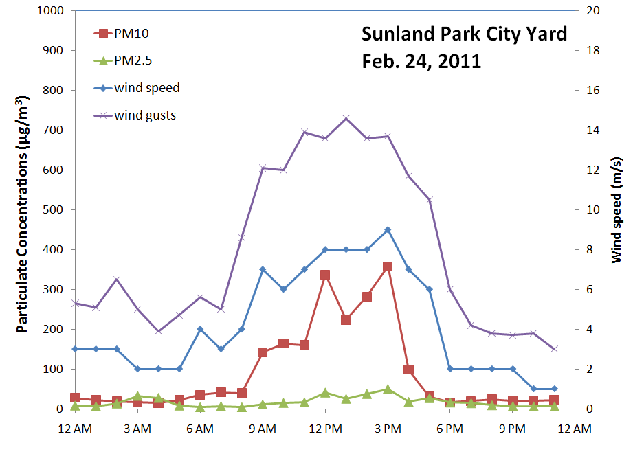
Here are the results from this wind storm. At the Sunland Park City Yard we saw peak PM10 reach 1153 µg/m3 and peak PM2.5 hit 92 µg/m3 at 3 pm.
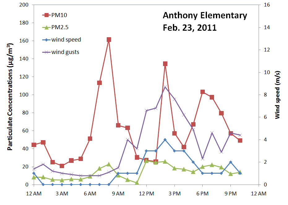
At the Anthony Elementary station the peak PM10 was higher than the Sunland Park station with a peak PM10 of 2154 µg/m3 and peak PM2.5 of 196 µg/m3 at 1 pm.
Further north at the Las Cruces west mesa station we see much lower concentrations and PM10 peaked at 238 µg/m3 at 5 pm. Peak wind gusts at 3pm were 19.6 m/s (44 mph)
At the Las Cruces Holman Road station we saw peak PM10 reach 489 µg/m3 at 2 pm. Peak wind gusts at that time were 21.1 m/s (47 mph).
Looking west at the Deming station we saw PM10 peak at 1028 µg/m3 at 1 pm. This station recorded the highest winds in the air quality network with wind gusts reaching 22.4 m/s (50 mph).