We see shortwave troughs all the time but I have never looked at the clouds overhead while the system moves across. In the afternoon you can see the movement of clouds from the west (coming toward the camera) but they start to come from the northwest and north later in the day. It's normal but it just looks odd while looking at the time-lapse.
The trough timing can be see clearly in the wind profiler data south of Deming.If you follow the wind directions around 3 km MSL you see they start with northwest winds, then by 21 UTC (2 pm) they are from the north and then by 02 UTC (7 pm) they are coming from the northeast. That's just about a 90 degree deviation.
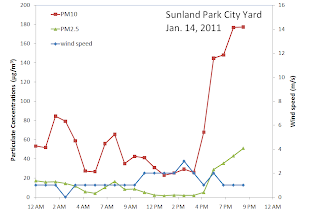
It doesn't come as a surprise that we see an evening low wind high PM event at the Sunland Park City Yard tonight
and at Anthony as well
and we see peak PM a little later at Chaparral
A low wind signature is not clearly seen at the core site today.
The AQI forecast for Saturday looks like air quality in the good range. I'm not complaining a bit about that.


No comments:
Post a Comment