


And here is the trace for Lordsburg for the same time period. Maximum winds at 20 UTC are 6.6 m/s.

So far this morning we have a low wind peak in particulates at the Sunland Park City Yard and Anthony sites.We also have a fairly strong temperature inversion based on the 12 UTC sounding at Santa Teresa. Graphic was obtained from the NCAR Real-Time Weather page.

I thought this is a nice example of a cold core high pressure over Chihuahua at 20 UTC (1 pm MST) today. You can see the surface wind divergence associated with high pressure. Remember that wind flows out of high pressure to low pressure. Temperatures are color coded with coldest temperatures in the blue/green and warm in yellows/orange. This is from the 14 UTC RUC model run.

The surface high was clearly marked in the 15 UTC weather map

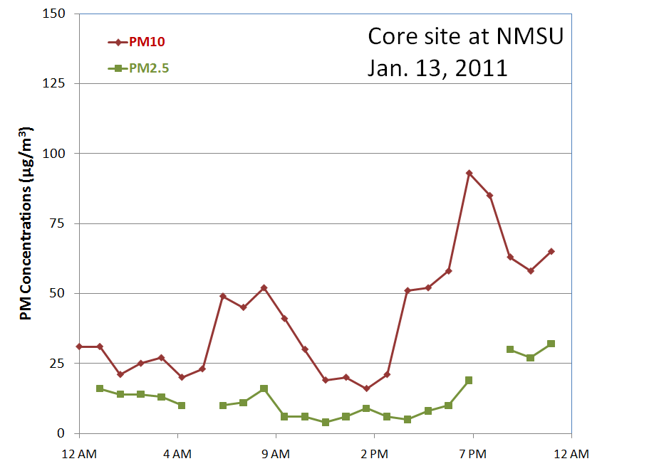
At the NMSU core site we saw an evening PM10 peak of 93 µg/m3 and PM2.5 of 30 µg/m3. The PM2.5 MetOne BAM has been missing a few hours here and there over the past few days. I'll have to take a look at it tomorrow. This instrument has been very reliable in the past 6 months.
And another low wind PM spike at the Sunland Park City Yard

and also at the NMED Anthony Elementary site

The evening peak signature goes away at the Las Cruces West Mesa station. This goes to show that PM tends to be higher in the valley than at the West Mesa site. The West Mesa site is 8.5 km directly west of the core site at the Garcia Horticultural farm.

The Las Cruces Holman Road site showed a different story with a 6 pm peak PM10 of 316 µg/m3. Winds were blowing from the east at the time of the spike and wind gusts were around 4 m/s.

The Holman Road site is surrounded by disturbed desert with unpaved roads to the east as shown below from Google Earth. I tend to think that this was caused by a local source rather than representative of the east mesa area although the timing is right and coincides with the other PM spikes across the valley.

The AQI at 11 pm MST shows a patch of moderate air quality over El Paso.

Tomorrow's AQI forecast looks like green (good) air quality.
No comments:
Post a Comment